
Faidhle:World 1914 empires colonies territory.PNG

Am faidhle tùsail (1,522 × 628 pixel, meud an fhaidhle: 45 KB, seòrsa MIME: image/png)

|
This map image could be re-created using vector graphics as an SVG file. This has several advantages; see Commons:Media for cleanup for more information. If an SVG form of this image is available, please upload it and afterwards replace this template with
{{vector version available|new image name}}.
It is recommended to name the SVG file “World 1914 empires colonies territory.svg”—then the template Vector version available (or Vva) does not need the new image name parameter. |
Gearr-chunntas
| Tuairisgeul |
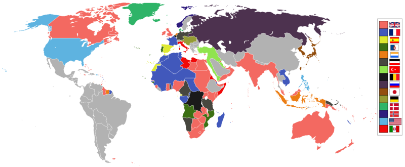
English: World empires and colonies in 1914, just before the First World War.
|
||||||||||||||||
| Ceann-là | |||||||||||||||||
| Tùs | M’ obair fhèin | ||||||||||||||||
| Ùghdar | Andrew0921 | ||||||||||||||||
.jpg)
._LOC_2001620596.jpg)
Ceadachadh
- Faodaidh tu:
- a cho-roinneadh – lethbhreac a dhèanamh dhen obair, a sgaoileadh is a tar-chur
- ath-mheasgachadh – an obair atharrachadh
- Fo bhuaidh nan cumhaichean a leanas:
- urram – Feumaidh tu iomradh a thoirt air an ùghdar no an neach aig a bheil cead air, dìreach mar a thoill iad (ach chan ann air dòigh a chuireas an sùilean dhaoine gu bheil iad ag aontachadh riut no ri d’ obair).
Eachdraidh an fhaidhle
Briog air ceann-là/àm gus am faidhle a shealltainn mar a nochd e aig an àm sin.
| Ceann-là/Àm | Dealbhag | Meud | Cleachdaiche | Beachd | |
|---|---|---|---|---|---|
| làithreach | 09:28, 8 dhen t-Samhain 2021 | | 1,522 × 628 (45 KB) | Randomastwritter | jubaland |
| 00:00, 14 dhen Ghiblean 2021 |  | 1,522 × 628 (45 KB) | Offa29 | Fixed Togoland colour | |
| 18:57, 24 dhen Ghiblean 2020 |  | 1,522 × 628 (45 KB) | The- | Norwegian flag | |
| 17:08, 24 dhen Ghiblean 2020 |  | 1,522 × 628 (45 KB) | The- | If an old map with wrongly drawn borders is replaced with a better map wth a minor colour error, then fix that minor colour error. Don't just blithely revert to the bad old map. | |
| 21:52, 17 dhen Mhàrt 2020 |  | 1,474 × 620 (36 KB) | Makkkkus | Replaced the Swedish-Norwegian union flag with the Norwegian flag. | |
| 19:25, 13 dhen Mhàrt 2020 |  | 1,474 × 620 (22 KB) | Morris-frank | The new version introduced a big regression (coloring spain in the color of italy), also it did not contribute anything useful. | |
| 21:49, 14 dhen Lùnastal 2019 |  | 1,522 × 628 (45 KB) | The- | More accurate map | |
| 12:47, 5 dhen Iuchar 2016 |  | 1,474 × 620 (22 KB) | Maproom | Removed borders between provinces of Australia, as requested at https://en.wikipedia.org/wiki/Wikipedia:Graphics_Lab/Map_workshop#FIFA_World_Cup_Maps_-_Colonial_Boundaries , because it had been united into a single dominion before 1914. | |
| 00:00, 26 dhen Dùbhlachd 2010 |  | 1,474 × 620 (33 KB) | Quigley | by 1914, Qing Dynasty had collapsed and Republic of China established | |
| 13:56, 22 dhen t-Samhain 2010 |  | 1,474 × 620 (20 KB) | AnonMoos | cropping margins, increasing PNG compression |
Cleachdadh an fhaidhle
Chan eil duilleag sam bith a' ceangal an-seo.
Cleachdadh fhaidhlichean uile-choitcheann
Tha na uicidhean eile a leanas a’ cleachdadh an fhaidhle seo
- Cleachdadh air af.wikipedia.org
- Cleachdadh air ar.wikipedia.org
- Cleachdadh air azb.wikipedia.org
- Cleachdadh air bn.wikipedia.org
- Cleachdadh air ca.wikipedia.org
- Cleachdadh air da.wikipedia.org
- Cleachdadh air en.wikipedia.org
- Cleachdadh air eo.wikipedia.org
- Cleachdadh air eo.wikiquote.org
- Cleachdadh air es.wikipedia.org
- Cleachdadh air fa.wikipedia.org
- Cleachdadh air fi.wikipedia.org
- Cleachdadh air fr.wikipedia.org
- Cleachdadh air fy.wikipedia.org
- Cleachdadh air gl.wikipedia.org
- Cleachdadh air hu.wikipedia.org
- Cleachdadh air it.wikipedia.org
- Cleachdadh air ja.wikipedia.org
- Cleachdadh air jv.wikipedia.org
- Cleachdadh air ka.wikipedia.org
- Cleachdadh air lv.wikipedia.org
- Cleachdadh air mk.wikipedia.org
- Cleachdadh air ml.wikipedia.org
- Cleachdadh air oc.wikipedia.org
- Cleachdadh air pt.wikipedia.org
- Cleachdadh air ro.wikipedia.org
Seall an corr dhen chleachdadh uile-choitcheann a nithear dhen fhaidhle seo.