
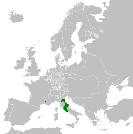
Faidhle:Papal States 1789.svg

Size of this PNG preview of this SVG file: 450 × 456 piogsail. Dùmhlachdan-breacaidh eile: 237 × 240 piogsail | 474 × 480 piogsail | 758 × 768 piogsail | 1,011 × 1,024 piogsail | 2,021 × 2,048 piogsail.
Am faidhle tùsail (Faidhle SVG, a-rèir ainm 450 × 456 pixel, meud faidhle: 799 KB)
Gearr-chunntas


.svg)
.svg)
.svg)
.svg)
.svg)


.svg)
.svg)
.svg)


.png)
.png)


.svg)


.svg)

.svg)


.svg)
.svg)
.svg)
.svg)


.svg)
.png)


.svg)


.svg)
.svg)


.svg)


.svg)


.svg)
.svg)
.svg)
.svg)
.svg)
.svg)
.svg)
_cropped.svg)
.svg)
.svg)
.svg)
.svg)
.svg)
.svg)
.svg)
.svg)
.svg)
.svg)
.svg)
.svg)
.svg)
.svg)
.svg)
.svg)
.svg)
.svg)
.svg)
.svg)
.svg)
.svg)
.svg)
.svg)
.svg)
.svg)
.svg)
.svg)
.svg)
.svg)
.svg)
.svg)
.svg)
.svg)
.svg)
.svg)
.svg)
.svg)
.svg)
.svg)
.svg)
.svg)
.svg)
.svg)
.svg)
Ceadachadh
I, the copyright holder of this work, hereby publish it under the following license:
Tha am faidhle seo fo cheadachas Creative Commons Attribution-Share Alike 3.0 Unported.
- Faodaidh tu:
- a cho-roinneadh – lethbhreac a dhèanamh dhen obair, a sgaoileadh is a tar-chur
- ath-mheasgachadh – an obair atharrachadh
- Fo bhuaidh nan cumhaichean a leanas:
- urram – Feumaidh tu iomradh a thoirt air an ùghdar no an neach aig a bheil cead air, dìreach mar a thoill iad (ach chan ann air dòigh a chuireas an sùilean dhaoine gu bheil iad ag aontachadh riut no ri d’ obair).
- co-roinneadh co-ionnann – Ma dh’atharraicheas tu no ma leasaicheas tu an obair seo, ’s urrainn an tionndadh ùr fon cheadachas seo no fo cheadachas coltach ris.
Original upload log
This image is a derivative work of the following images:
- File:Europe_1789.svg licensed with Cc-by-sa-3.0
- 2013-04-14T03:44:26Z Alphathon 450x456 (858577 Bytes) Corrected some errors in northern Italy
- 2013-04-14T01:38:01Z Alphathon 450x456 (853881 Bytes) tweaked again
- 2013-04-14T01:36:10Z Alphathon 450x456 (853881 Bytes) Tweaked Holy Roman Empire border style
- 2013-04-14T01:33:26Z Alphathon 450x456 (853857 Bytes) == {{int:filedesc}} == {{Information |Description={{en|A blank Map of Europe circa 1789. This map also includes a border for the [[:en:Holy Roman Empire|Holy Roman Empire]]. Since there are so many small German states, they h
Uploaded with derivativeFX
Eachdraidh an fhaidhle
Briog air ceann-là/àm gus am faidhle a shealltainn mar a nochd e aig an àm sin.
| Ceann-là/Àm | Dealbhag | Meud | Cleachdaiche | Beachd | |
|---|---|---|---|---|---|
| làithreach | 07:58, 17 dhen Dàmhair 2021 | | 450 × 456 (799 KB) | Fenn-O-maniC | Fixed the Russo-Swedish border to match the Treaty of Åbo of 1743 |
| 16:29, 18 dhen Ghiblean 2013 |  | 450 × 456 (820 KB) | Alphathon | Various fixes (see blank version) | |
| 04:00, 14 dhen Ghiblean 2013 |  | 450 × 456 (802 KB) | Alphathon | == {{int:filedesc}} == {{Information |Description={{en|A map the Papal States circa 1789.}}{{de|Eine Landkarte die Kirchenstaat c. 1989.}} |Source={{Derived from|Europe_1789.svg|display=50}} |Date=2013-04-14 03... |
Cleachdadh an fhaidhle
Chan eil duilleag sam bith a' ceangal an-seo.
Cleachdadh fhaidhlichean uile-choitcheann
Tha na uicidhean eile a leanas a’ cleachdadh an fhaidhle seo
- Cleachdadh air ast.wikipedia.org
- Cleachdadh air cdo.wikipedia.org
- Cleachdadh air cs.wikipedia.org
- Cleachdadh air en.wikipedia.org
- Cleachdadh air fr.wikipedia.org
- Cleachdadh air ga.wikipedia.org
- Cleachdadh air gl.wikipedia.org
- Cleachdadh air he.wikipedia.org
- Cleachdadh air hr.wikipedia.org
- Cleachdadh air ja.wikipedia.org
- Cleachdadh air ka.wikipedia.org
- Cleachdadh air ko.wikipedia.org
- Cleachdadh air mk.wikipedia.org
- Cleachdadh air oc.wikipedia.org
- Cleachdadh air sq.wikipedia.org
- Cleachdadh air tg.wikipedia.org
- Cleachdadh air ur.wikipedia.org
- Cleachdadh air www.wikidata.org
- Cleachdadh air xmf.wikipedia.org
- Cleachdadh air zh-min-nan.wikipedia.org
- Cleachdadh air zh.wikipedia.org