
Faidhle:Germanic tribes (750BC-1AD).png
Chan eil dùmhlachd-bhreacaidh nas fhearr ri fhaighinn.
Germanic_tribes_(750BC-1AD).png (537 × 376 pixel, meud an fhaidhle: 10 KB, seòrsa MIME: image/png)
.png)
Gearr-chunntas

|
File:Germanic tribes settlements 750BC-1AD.svg is a vector version of this file. It should be used in place of this PNG file when not inferior.
File:Germanic tribes (750BC-1AD).png → File:Germanic tribes settlements 750BC-1AD.svg
For more information, see Help:SVG. |
 |
| Tuairisgeul |
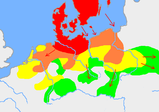
English: Based on p. 108 in the Penguin Atlas of World History, volume 1, from the Beginning to the Eve of the French Revolution. 1988. ISBN 0-14-051054-0. Note that the map assumes that the Nordwestblock was Germanized before 500 BC. This is uncertain; alternative proposals hold that the area near the mouths of the Rhine came under a Germanic superstate only in the 1st century BC.
The map is drawn on en:User:Dbachmann's blank map: en:Image:Europe plain rivers.png Settlements before 750 bc
New settlements by 500 bc
New settlements by 250 bc
New settlements by ad 1
Archived copy of a version of the original map. |
| Ceann-là | 21 dhen Fhaoilleach 2007 (original upload date) |
| Tùs | Transferred from en.wikipedia to Commons. |
| Ùghdar | Berig at Beurla Uicipeid |
see also Image:Pre Migration Age Germanic.png
Ceadachadh
I, Berig, the copyright holder of this work, hereby publishes it under the following licenses:

|
Permission is granted to copy, distribute and/or modify this document under the terms of the GNU Free Documentation License, Version 1.2 or any later version published by the Free Software Foundation; with no Invariant Sections, no Front-Cover Texts, and no Back-Cover Texts. A copy of the license is included in the section entitled GNU Free Documentation License. |
| Tha am faidhle seo fo cheadachas Creative Commons Attribution-Share Alike 3.0 Unported. | ||
| Urram: I, Berig | ||
| ||
| This licensing tag was added to this file as part of the GFDL licensing update. |
This file is licensed under the Creative Commons Attribution 2.5 Generic license.
Urram: I, Berig
- Faodaidh tu:
- a cho-roinneadh – lethbhreac a dhèanamh dhen obair, a sgaoileadh is a tar-chur
- ath-mheasgachadh – an obair atharrachadh
- Fo bhuaidh nan cumhaichean a leanas:
- urram – Feumaidh tu iomradh a thoirt air an ùghdar no an neach aig a bheil cead air, dìreach mar a thoill iad (ach chan ann air dòigh a chuireas an sùilean dhaoine gu bheil iad ag aontachadh riut no ri d’ obair).
’S urrainn dhut an ceadachas as fhearr leat a thaghadh.
Original upload log
The original description page was here. All following user names refer to en.wikipedia.
- 2007-01-21 10:52 Berig 537×376×8 (18448 bytes) Based on p. 108 in the Penguin Atlas of World History, volume 1, from the Beginning to the Eve of the French Revolution. 1988. The map is drawn on [[User:Dbachmann]]'s blank map: [[:Image:Europe plain rivers.png]]
Eachdraidh an fhaidhle
Briog air ceann-là/àm gus am faidhle a shealltainn mar a nochd e aig an àm sin.
| Ceann-là/Àm | Dealbhag | Meud | Cleachdaiche | Beachd | |
|---|---|---|---|---|---|
| làithreach | 00:34, 17 dhen Ghearran 2009 | | 537 × 376 (10 KB) | Disposable.Heroes | pngcrush |
| 17:17, 11 dhen Mhàrt 2007 |  | 537 × 376 (18 KB) | R9tgokunks | {{Information |Description=Based on p. 108 in the Penguin Atlas of World History, volume 1, from the Beginning to the Eve of the French Revolution. 1988. ISBN 0-14-051054-0 The map is drawn on en:User:Dbachmann's blank map: [[:en::Image:Europe plain | |
| 20:17, 11 dhen Ghearran 2007 |  | 537 × 376 (18 KB) | Electionworld | {{Information |Description=Based on p. 108 in the Penguin Atlas of World History, volume 1, from the Beginning to the Eve of the French Revolution. 1988. ISBN 0-14-051054-0 The map is drawn on en:User:Dbachmann's blank map: [[:en::Image:Europe plain |
Cleachdadh an fhaidhle
Chan eil duilleag sam bith a' ceangal an-seo.
Cleachdadh fhaidhlichean uile-choitcheann
Tha na uicidhean eile a leanas a’ cleachdadh an fhaidhle seo
- Cleachdadh air af.wikipedia.org
- Cleachdadh air ar.wikipedia.org
- Cleachdadh air ast.wikipedia.org
- Cleachdadh air av.wikipedia.org
- Cleachdadh air azb.wikipedia.org
- Cleachdadh air bg.wikipedia.org
- Cleachdadh air bn.wikipedia.org
- Cleachdadh air bs.wikipedia.org
- Cleachdadh air ca.wikipedia.org
- Cleachdadh air ckb.wikipedia.org
- Cleachdadh air cv.wikipedia.org
- Cleachdadh air de.wikipedia.org
- Cleachdadh air el.wikipedia.org
- Cleachdadh air en.wikipedia.org
- Bastarnae
- Celts
- Germanic languages
- Germanic peoples
- History of Germany
- History of the Netherlands
- Lombards
- AD 1
- 250 BC
- Marchian
- Eastphalian language
- Proto-Germanic language
- Ruhrdeutsch
- East Germanic languages
- Talk:Germania
- Benrath line
- Lexin
- Vadstena bracteate
- Svealand dialects
- Leew Eilun Feer
- South Franconian German
- Highest Alemannic German
- Moselle Franconian language
- Stellingwarfs dialect
Seall an corr dhen chleachdadh uile-choitcheann a nithear dhen fhaidhle seo.
.png)
.png)