Faidhle:Geographic distribution of Bengali language.png

Page contents not supported in other languages.
O Uicipeid

Am faidhle tùsail(2,806 × 2,080 pixel, meud an fhaidhle: 1.36 MB, seòrsa MIME: image/png)

'S ann à Wikimedia Commons a tha am faidhle seo agus faodaidh gu bheil pròiseactan eile 'ga chleachdadh. Chì thu an tuairisgeul a tha aice air [duilleag tuairisgeul an fhaidhle https://commons.wikimedia.org/wiki/File:Geographic_distribution_of_Bengali_language.png] gu h-ìosal.

Gearr-chunntas

Tuairisgeul
Ελληνικά: Γεωγραφική κατανομή της Βεγγαλικής Γλώσσας ανά επαρχία της Ινδίας και στο Μπανγκλαντές, τα χρώματα στις επαρχίες ποικίλουν ανάλογα με το ποσοστό ομιλητών (δεδομένα απογραφής 2011). Παράγωγο του αρχείου India district map (de-facto).svg.
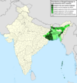
English: Geographic distribution of Bengali language in India and Bangladesh. The map covers each district of India and the five shades of green show the percentage of Bengali language speakers in each district. Source: Indian census 2011. Feel free to enrich the map with data for more Indian districts, or fix any mistakes. Derivative of the file India district map (de-facto).svg.
Ceann-là
Tùs M’ obair fhèin
Ùghdar NikosLikomitros

Ceadachadh

I, the copyright holder of this work, hereby publish it under the following license:
w:en:Creative Commons
urram co-roinneadh co-ionnann
This file is licensed under the Creative Commons Attribution-Share Alike 4.0 International license.
Faodaidh tu:
  • a cho-roinneadh – lethbhreac a dhèanamh dhen obair, a sgaoileadh is a tar-chur
  • ath-mheasgachadh – an obair atharrachadh
Fo bhuaidh nan cumhaichean a leanas:
  • urram – Feumaidh tu iomradh a thoirt air an ùghdar no an neach aig a bheil cead air, dìreach mar a thoill iad (ach chan ann air dòigh a chuireas an sùilean dhaoine gu bheil iad ag aontachadh riut no ri d’ obair).
  • co-roinneadh co-ionnann – Ma dh’atharraicheas tu no ma leasaicheas tu an obair seo, ’s urrainn an tionndadh ùr fon cheadachas seo no fo cheadachas coltach ris.

Captions

Add a one-line explanation of what this file represents
Geographic distribution of Bengali language in India and Bangladesh. The map covers each district of India and the five shades of green show the percentage of Bengali language speakers in each district. Source: Indian census 2011.

Items portrayed in this file

depicts Beurla

26 dhen Ògmhios 2022

media type Beurla

image/png

Eachdraidh an fhaidhle

Briog air ceann-là/àm gus am faidhle a shealltainn mar a nochd e aig an àm sin.

Ceann-là/ÀmDealbhagMeudCleachdaicheBeachd
làithreach15:05, 2 dhen Iuchar 2022Dealbhag airson an tionndaidh on 15:05, 2 dhen Iuchar 20222,806 × 2,080 (1.36 MB)NikosLikomitrosA few districts of Arunachal Pradesh have a notable Bengali presence above of 1%, probably part of the Indian efforts to increase its presence in the region.
16:55, 1 dhen Iuchar 2022Dealbhag airson an tionndaidh on 16:55, 1 dhen Iuchar 20222,806 × 2,080 (1.36 MB)NikosLikomitrosTwo extra fixes.
16:53, 1 dhen Iuchar 2022Dealbhag airson an tionndaidh on 16:53, 1 dhen Iuchar 20222,806 × 2,080 (1.36 MB)NikosLikomitrosMinor fixes.
16:44, 1 dhen Iuchar 2022Dealbhag airson an tionndaidh on 16:44, 1 dhen Iuchar 20222,806 × 2,080 (1.36 MB)NikosLikomitrosNow, this map covers all districts of India. Includes also extra information and a new colour key. The basemap is from Distribution_of_Jats_in_South_Asia.png.
21:09, 26 dhen Ògmhios 2022Dealbhag airson an tionndaidh on 21:09, 26 dhen Ògmhios 20221,902 × 2,048 (1,002 KB)NikosLikomitrosUploaded own work with UploadWizard

Chan eil duilleag sam bith a' ceangal an-seo.

Cleachdadh fhaidhlichean uile-choitcheann

Tha na uicidhean eile a leanas a’ cleachdadh an fhaidhle seo

Metadata