
Faidhle:Ti-map.gif

Chan eil dùmhlachd-bhreacaidh nas fhearr ri fhaighinn.
Ti-map.gif (634 × 324 pixel, meud an fhaidhle: 19 KB, seòrsa MIME: image/gif)
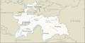
English: CIA map of Tajikistan (This version of the map does not includes significant changes made in the newer version of the map including changes to the China-Tajikistan border.)
-
 Current version (includes changes to China-Tajikistan boundary)

This image is in the public domain because it contains materials that originally came from the United States Central Intelligence Agency's World Factbook.
|
 |
Eachdraidh an fhaidhle
Briog air ceann-là/àm gus am faidhle a shealltainn mar a nochd e aig an àm sin.
| Ceann-là/Àm | Dealbhag | Meud | Cleachdaiche | Beachd | |
|---|---|---|---|---|---|
| làithreach | 12:27, 28 dhen Mhàrt 2005 | | 634 × 324 (19 KB) | Poulpy | CIA map of Tajikistan {{PD-USGov-CIA-WF}} Category:Tajikistan |
Cleachdadh an fhaidhle
Chan eil duilleag sam bith a' ceangal an-seo.
Cleachdadh fhaidhlichean uile-choitcheann
Tha na uicidhean eile a leanas a’ cleachdadh an fhaidhle seo
- Cleachdadh air azb.wikipedia.org
- Cleachdadh air ca.wikipedia.org
- Cleachdadh air ckb.wikipedia.org
- Cleachdadh air en.wikipedia.org
- Cleachdadh air fa.wikipedia.org
- Cleachdadh air fr.wikipedia.org
- Cleachdadh air he.wikinews.org
- Cleachdadh air hu.wikipedia.org
- Cleachdadh air id.wikipedia.org
- Cleachdadh air ja.wikipedia.org
- Cleachdadh air mzn.wikipedia.org
- Cleachdadh air nl.wikipedia.org
- Cleachdadh air no.wikipedia.org
- Cleachdadh air pa.wikipedia.org
- Cleachdadh air tg.wikipedia.org
- Cleachdadh air uz.wikipedia.org
- Cleachdadh air www.wikidata.org
- Cleachdadh air zh.wikipedia.org