
Faidhle:Sweden Jönköping location map.svg

Size of this PNG preview of this SVG file: 600 × 600 piogsail. Dùmhlachdan-breacaidh eile: 240 × 240 piogsail | 480 × 480 piogsail | 768 × 768 piogsail | 1,024 × 1,024 piogsail | 2,048 × 2,048 piogsail | 1,019 × 1,019 piogsail.
Am faidhle tùsail (Faidhle SVG, a-rèir ainm 1,019 × 1,019 pixel, meud faidhle: 92 KB)
Gearr-chunntas
| Tuairisgeul |
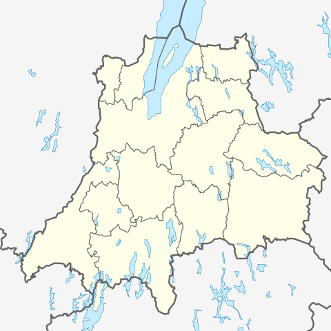
English: Location map of Jönköping County in Sweden
Equirectangular projection, N/S stretching 187 %. Geographic limits of the map:
Deutsch: Positionskarte von Jönköpings län in Schweden
Quadratische Plattkarte, N-S-Streckung 187 %. Geographische Begrenzung der Karte:
|
| Ceann-là | |
| Tùs | M’ obair fhèin |
| Ùghdar | Erik Frohne |
Ceadachadh
I, the copyright holder of this work, hereby publish it under the following licenses:

|
Permission is granted to copy, distribute and/or modify this document under the terms of the GNU Free Documentation License, Version 1.2 or any later version published by the Free Software Foundation; with no Invariant Sections, no Front-Cover Texts, and no Back-Cover Texts. A copy of the license is included in the section entitled GNU Free Documentation License. |
This file is licensed under the Creative Commons Attribution 3.0 Unported license.
- Faodaidh tu:
- a cho-roinneadh – lethbhreac a dhèanamh dhen obair, a sgaoileadh is a tar-chur
- ath-mheasgachadh – an obair atharrachadh
- Fo bhuaidh nan cumhaichean a leanas:
- urram – Feumaidh tu iomradh a thoirt air an ùghdar no an neach aig a bheil cead air, dìreach mar a thoill iad (ach chan ann air dòigh a chuireas an sùilean dhaoine gu bheil iad ag aontachadh riut no ri d’ obair).
’S urrainn dhut an ceadachas as fhearr leat a thaghadh.
Eachdraidh an fhaidhle
Briog air ceann-là/àm gus am faidhle a shealltainn mar a nochd e aig an àm sin.
| Ceann-là/Àm | Dealbhag | Meud | Cleachdaiche | Beachd | |
|---|---|---|---|---|---|
| làithreach | 19:02, 20 dhen Fhaoilleach 2009 | | 1,019 × 1,019 (92 KB) | Erik Frohne | {{Information |Description={{en|1=Location map of Jönköping in Sweden Equirectangular projection, N/S stretching 187 %. Geographic limits of the map: * N: 58.30° N * S: 56.80° N * W: 12.90° E * E: 15.70° E }} {{de|1=Positionskarte von Jönköping |
Cleachdadh an fhaidhle
Tha ceangal ris an fhaidhle seo san duilleag a leanas:
Cleachdadh fhaidhlichean uile-choitcheann
Tha na uicidhean eile a leanas a’ cleachdadh an fhaidhle seo
- Cleachdadh air ar.wikipedia.org
- Cleachdadh air bg.wikipedia.org
- Cleachdadh air ceb.wikipedia.org
- Cleachdadh air cs.wikipedia.org
- Cleachdadh air da.wikipedia.org
- Cleachdadh air de.wikipedia.org
Seall an corr dhen chleachdadh uile-choitcheann a nithear dhen fhaidhle seo.