
Faidhle:Skye map.PNG
Chan eil dùmhlachd-bhreacaidh nas fhearr ri fhaighinn.
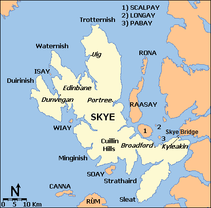
Skye_map.PNG (433 × 427 pixel, meud an fhaidhle: 22 KB, seòrsa MIME: image/png)

|
This locator map image could be re-created using vector graphics as an SVG file. This has several advantages; see Commons:Media for cleanup for more information. If an SVG form of this image is available, please upload it and afterwards replace this template with
{{vector version available|new image name}}.
It is recommended to name the SVG file “Skye map.svg”—then the template Vector version available (or Vva) does not need the new image name parameter. |
| Tuairisgeul | |||||||||
| Ceann-là | |||||||||
| Tùs | M’ obair fhèin | ||||||||
| Ùghdar | Ruhrfisch | ||||||||
| Cead (Ag ath-chleachdadh an fhaidhle seo) |
I, the copyright holder of this work, hereby publish it under the following license:
|
||||||||
| Other versions |
 |

Eachdraidh an fhaidhle
Briog air ceann-là/àm gus am faidhle a shealltainn mar a nochd e aig an àm sin.
| Ceann-là/Àm | Dealbhag | Meud | Cleachdaiche | Beachd | |
|---|---|---|---|---|---|
| làithreach | 18:31, 12 dhen Fhaoilleach 2013 | | 433 × 427 (22 KB) | Ruhrfisch | Try this again - add Skye Bridge to map |
| 18:25, 12 dhen Fhaoilleach 2013 |  | 433 × 427 (22 KB) | Ruhrfisch | Add Skye Bridge and label per FAC, no other changes | |
| 20:57, 23 dhen Ògmhios 2008 |  | 433 × 427 (18 KB) | Ruhrfisch | {{Information |Description={{en|1=Map of the Isle of Skye and surroundings, based on a public domain original map, generated at [http://www.aquarius.geomar.de/omc/make_map.html OMC]. }} |Source=Own work by uploader |Author=[[User:Ruhrfisch|Ru |
Cleachdadh an fhaidhle
Chan eil duilleag sam bith a' ceangal an-seo.
Cleachdadh fhaidhlichean uile-choitcheann
Tha na uicidhean eile a leanas a’ cleachdadh an fhaidhle seo
- Cleachdadh air br.wikipedia.org
- Cleachdadh air de.wikipedia.org
- Cleachdadh air de.wikivoyage.org
- Cleachdadh air en.wikipedia.org
- Cleachdadh air fr.wikipedia.org
- Cleachdadh air it.wikivoyage.org
- Cleachdadh air simple.wikipedia.org