Faidhle:Skagerrak 2 ubt.jpg

Page contents not supported in other languages.
O Uicipeid

Skagerrak_2_ubt.jpg(416 × 433 pixel, meud an fhaidhle: 67 KB, seòrsa MIME: image/jpeg)

'S ann à Wikimedia Commons a tha am faidhle seo agus faodaidh gu bheil pròiseactan eile 'ga chleachdadh. Chì thu an tuairisgeul a tha aice air [duilleag tuairisgeul an fhaidhle https://commons.wikimedia.org/wiki/File:Skagerrak_2_ubt.jpg] gu h-ìosal.

Gearr-chunntas

Tuairisgeul
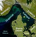
Polski: Satelitarne zdjęcie cieśnin Kattegat i Skagerrak z polskim opisem.
English: Satellite photo and map of the straits of Kattegat and Skagerrak — in the North Sea between Denmark, Sweden, and Norway.
  • The straits drain the Baltic Sea into the Atlantic Ocean.
Tùs NASA
The original (unprocessed) file is available at http://visibleearth.nasa.gov/view_rec.php?vev1id=25413
Ùghdar NASA
Polski: polskie opisy dodane przez tsca
Cead
(Ag ath-chleachdadh an fhaidhle seo)
PD-NASA.

Ceadachadh

Public domain This file is in the public domain in the United States because it was solely created by NASA. NASA copyright policy states that "NASA material is not protected by copyright unless noted". (See Template:PD-USGov, NASA copyright policy page or JPL Image Use Policy.)
Warnings:

Eachdraidh an fhaidhle

Briog air ceann-là/àm gus am faidhle a shealltainn mar a nochd e aig an àm sin.

Ceann-là/ÀmDealbhagMeudCleachdaicheBeachd
làithreach20:50, 5 dhen Mhàrt 2009Dealbhag airson an tionndaidh on 20:50, 5 dhen Mhàrt 2009416 × 433 (67 KB)File Upload Bot (Magnus Manske) {{BotMoveToCommons|pl.wikipedia|year={{subst:CURRENTYEAR}}|month={{subst:CURRENTMONTHNAME}}|day={{subst:CURRENTDAY}}}} {{Information |Description={{pl|''no original description''}} |Source=Transferred from [http://pl.wikipedia.org pl.wikipedia]; transfer

Tha ceangal ris an fhaidhle seo san duilleag a leanas:

Cleachdadh fhaidhlichean uile-choitcheann

Tha na uicidhean eile a leanas a’ cleachdadh an fhaidhle seo

Metadata