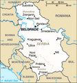
Faidhle:Serbia-CIA WFB Map 2006.png
Serbia-CIA_WFB_Map_2006.png (328 × 352 pixel, meud an fhaidhle: 24 KB, seòrsa MIME: image/png)
Eachdraidh an fhaidhle
Briog air ceann-là/àm gus am faidhle a shealltainn mar a nochd e aig an àm sin.
| Ceann-là/Àm | Dealbhag | Meud | Cleachdaiche | Beachd | |
|---|---|---|---|---|---|
| làithreach | 18:03, 15 dhen Ògmhios 2017 |  | 328 × 352 (24 KB) | Кликери | Reverted to version as of 09:17, 20 June 2009 (UTC) |
| 16:56, 15 dhen Ògmhios 2017 |  | 326 × 350 (33 KB) | Hakuli | Serbia map - CIA 2017 | |
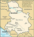
| 09:17, 20 dhen Ògmhios 2009 |  | 328 × 352 (24 KB) | Mike Babic~commonswiki | {{Information |Description=CIA World Factbook map from 2006. It shows Kosovo as an autonomous province of Serbia. Kosovo declared itself independence on February 17, 2008. This is recognized by the United States and some other nations. The most recent | |
| 13:27, 25 dhen Mhàrt 2008 |  | 328 × 352 (16 KB) | Mattflaschen | {{Information |Description=CIA World Factbook map from 2006. It shows Serbia as an autonomous province of Serbia. Kosovo declared itself independence on February 17, 2008. This is recognized by the United States and some other nations. The most recent |
Cleachdadh an fhaidhle
Chan eil duilleag sam bith a' ceangal an-seo.
Cleachdadh fhaidhlichean uile-choitcheann
Tha na uicidhean eile a leanas a’ cleachdadh an fhaidhle seo
- Cleachdadh air ca.wikipedia.org
- Cleachdadh air de.wikipedia.org
- Cleachdadh air en.wikipedia.org
- Cleachdadh air fa.wikipedia.org
- Cleachdadh air hr.wikipedia.org
- Cleachdadh air ja.wikipedia.org
- Cleachdadh air mk.wikipedia.org
- Cleachdadh air ms.wikipedia.org
- Ada (Serbia)
- Mol (Serbia)
- Obornjača (Ada)
- Utrine (Ada)
- Cerovac (Aerodrom)
- Aerodrom, Kragujevac
- Cvetojevac
- Čumić
- Desimirovac
- Donje Grbice
- Gornje Grbice
- Gornje Jarušice
- Jovanovac (Aerodrom)
- Lužnice (Aerodrom)
- Mali Šenj
- Mironić
- Novi Milanovac
- Opornica
- Pajazitovo
- Poskurice
- Resnik (Aerodrom)
- Šljivovac (Aerodrom)
- Aleksandrovac
- Bobote
- Boturići
- Dobroljubci
- Bratići
- Bzenice
- Dašnica (Aleksandrovac)
- Donja Zleginja
- Donje Rataje
- Donji Stupanj
- Donji Vratari
Seall an corr dhen chleachdadh uile-choitcheann a nithear dhen fhaidhle seo.


