
Faidhle:Map-brochs.png
Chan eil dùmhlachd-bhreacaidh nas fhearr ri fhaighinn.
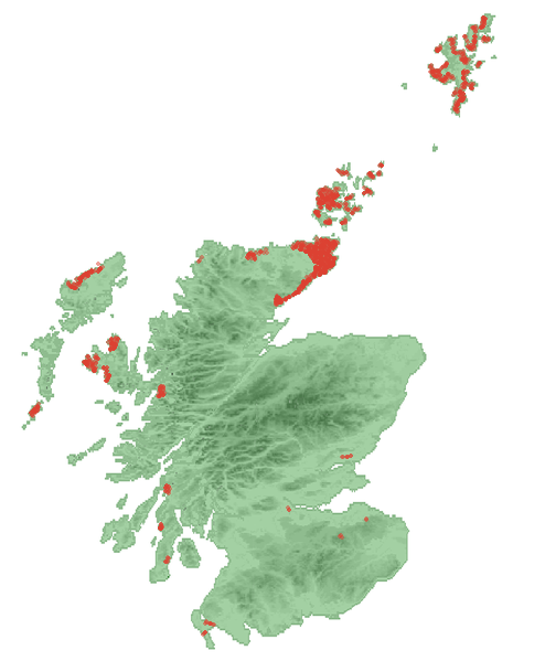
Map-brochs.png (494 × 599 pixel, meud an fhaidhle: 118 KB, seòrsa MIME: image/png)
Gearr-chunntas
| Tuairisgeul |
English: Approximate locations of the brochs in Scotland |
| Ceann-là | |
| Tùs | The map was made by Anameofmyveryown and can be found in the WikipediaCommons (Scotland_locator_map_2007-09-03_-_equidistant_cylindrical_stretched_150percent_vertically.png). That original was based on 1) an equidistant cylindrical projection map from -8W to 0E, 54.5N to 61N, created from public domain map engine at http://www.aquarius.geomar.de/omc/ on 2007-08-23 and 2) Image:Scotland (Location) Template (HR).png by User:SFC9394 which had a GFDL license on 2007-09-03. The locations of the brochs were added by Bubobubo2. |
| Ùghdar | Bubobubo2, see also comment at original source. |
_Template_(HR).png)
Ceadachadh

|
Permission is granted to copy, distribute and/or modify this document under the terms of the GNU Free Documentation License, Version 1.2 or any later version published by the Free Software Foundation; with no Invariant Sections, no Front-Cover Texts, and no Back-Cover Texts. A copy of the license is included in the section entitled GNU Free Documentation License. |
| Tha am faidhle seo fo cheadachas Creative Commons Attribution-Share Alike 3.0 Unported. | ||
| ||
| This licensing tag was added to this file as part of the GFDL licensing update. |
Eachdraidh an fhaidhle
Briog air ceann-là/àm gus am faidhle a shealltainn mar a nochd e aig an àm sin.
| Ceann-là/Àm | Dealbhag | Meud | Cleachdaiche | Beachd | |
|---|---|---|---|---|---|
| làithreach | 19:29, 5 dhen Fhaoilleach 2009 | | 494 × 599 (118 KB) | Bubobubo2 | {{Information |Description={{en|1=Approximate locations of the brochs in Scotland}} |Source=The map was made by Anameofmyveryown and can be found in the WikipediaCommons (Scotland_locator_map_2007-09-03_-_equidistant_cylindrical_ |
Cleachdadh an fhaidhle
Tha ceangal ris an fhaidhle seo san duilleag a leanas:
Cleachdadh fhaidhlichean uile-choitcheann
Tha na uicidhean eile a leanas a’ cleachdadh an fhaidhle seo
- Cleachdadh air bg.wikipedia.org
- Cleachdadh air cs.wikipedia.org
- Cleachdadh air de.wikipedia.org
- Cleachdadh air en.wikipedia.org
- Cleachdadh air eo.wikipedia.org
- Cleachdadh air fa.wikipedia.org
- Cleachdadh air fr.wikipedia.org
- Cleachdadh air fy.wikipedia.org
- Cleachdadh air ga.wikipedia.org
- Cleachdadh air it.wikipedia.org
- Cleachdadh air nl.wikipedia.org
- Cleachdadh air no.wikipedia.org
- Cleachdadh air pt.wikipedia.org
- Cleachdadh air ru.wikipedia.org
- Cleachdadh air sl.wikipedia.org
- Cleachdadh air sv.wikipedia.org
- Cleachdadh air uk.wikipedia.org
- Cleachdadh air www.wikidata.org