
Faidhle:Karte Lueneburger Heide.png
Meud an ro-sheallaidh seo: 648 × 599 piogsail. Dùmhlachdan-breacaidh eile: 260 × 240 piogsail | 519 × 480 piogsail | 831 × 768 piogsail | 1,089 × 1,007 piogsail.
Am faidhle tùsail (1,089 × 1,007 pixel, meud an fhaidhle: 1.34 MB, seòrsa MIME: image/png)
Gearr-chunntas
| Tuairisgeul |
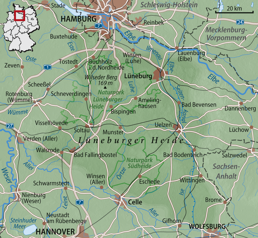
Deutsch: Übersichtskarte der Lüneburger Heide
English: Map of Lüneburg Heath |
| Ceann-là | |
| Tùs | M’ obair fhèin, using www.maps-for-free.com |
| Ùghdar | NordNordWest |

|
This map has been made or improved in the German Kartenwerkstatt (Map Lab). You can propose maps to improve as well.
|
Ceadachadh
I, the copyright holder of this work, hereby publish it under the following licenses:

|
Permission is granted to copy, distribute and/or modify this document under the terms of the GNU Free Documentation License, Version 1.2 or any later version published by the Free Software Foundation; with no Invariant Sections, no Front-Cover Texts, and no Back-Cover Texts. A copy of the license is included in the section entitled GNU Free Documentation License. |
Tha am faidhle seo fo cheadachas Creative Commons Attribution-Share Alike 3.0 Unported.
- Faodaidh tu:
- a cho-roinneadh – lethbhreac a dhèanamh dhen obair, a sgaoileadh is a tar-chur
- ath-mheasgachadh – an obair atharrachadh
- Fo bhuaidh nan cumhaichean a leanas:
- urram – Feumaidh tu iomradh a thoirt air an ùghdar no an neach aig a bheil cead air, dìreach mar a thoill iad (ach chan ann air dòigh a chuireas an sùilean dhaoine gu bheil iad ag aontachadh riut no ri d’ obair).
- co-roinneadh co-ionnann – Ma dh’atharraicheas tu no ma leasaicheas tu an obair seo, ’s urrainn an tionndadh ùr fon cheadachas seo no fo cheadachas coltach ris.
’S urrainn dhut an ceadachas as fhearr leat a thaghadh.
Eachdraidh an fhaidhle
Briog air ceann-là/àm gus am faidhle a shealltainn mar a nochd e aig an àm sin.
| Ceann-là/Àm | Dealbhag | Meud | Cleachdaiche | Beachd | |
|---|---|---|---|---|---|
| làithreach | 15:41, 21 dhen Chèitean 2008 | | 1,089 × 1,007 (1.34 MB) | NordNordWest | |
| 18:20, 19 dhen Chèitean 2008 |  | 1,089 × 1,007 (1.32 MB) | NordNordWest | ||
| 17:44, 19 dhen Chèitean 2008 |  | 1,089 × 1,006 (1.31 MB) | NordNordWest | {{Information |Description= {{de}} Übersichtskarte der Lüneburger Heide {{en}} Map of Lüneburg Heath |Source=own work, using * www.maps-for-free.com |Date=19-05-2008 |Author= [[User:Titus Groan|Titus |
Cleachdadh an fhaidhle
Tha ceangal ris an fhaidhle seo san duilleag a leanas:
Cleachdadh fhaidhlichean uile-choitcheann
Tha na uicidhean eile a leanas a’ cleachdadh an fhaidhle seo
- Cleachdadh air be.wikipedia.org
- Cleachdadh air bg.wikipedia.org
- Cleachdadh air ca.wikipedia.org
- Cleachdadh air cy.wikipedia.org
- Cleachdadh air da.wikipedia.org
- Cleachdadh air de.wikipedia.org
- Lüneburger Heide
- Uelzen
- Naturpark Lüneburger Heide
- Wikipedia:Kartenwerkstatt/Archiv/2008-05
- Wikipedia:Kandidaten für exzellente Bilder/Archiv2008/15
- Golaida
- Lüßwald
- Benutzer:Aeroid/List DE NI-WL
- Benutzer:Aeroid/List DE NI-HK
- Benutzer:Aeroid/List DE NI-CE
- Benutzer:Aeroid/List DE NI-GF
- Benutzer:Aeroid/Geo North European Plain
- Benutzer:Aeroid/Natural region DE 64
- Benutzer:Aeroid/List DE NI Natural region
- Cleachdadh air en.wikipedia.org
- Cleachdadh air en.wikivoyage.org
- Cleachdadh air eo.wikipedia.org
- Cleachdadh air es.wikipedia.org
- Cleachdadh air et.wikipedia.org
- Cleachdadh air fr.wikipedia.org
- Cleachdadh air fy.wikipedia.org
- Cleachdadh air hu.wikipedia.org
- Cleachdadh air it.wikipedia.org
- Cleachdadh air it.wikivoyage.org
- Cleachdadh air mk.wikipedia.org
- Cleachdadh air nds.wikipedia.org
- Cleachdadh air nl.wikipedia.org
- Cleachdadh air nn.wikipedia.org
- Cleachdadh air no.wikipedia.org
- Cleachdadh air pl.wikipedia.org
- Cleachdadh air pl.wikivoyage.org
- Cleachdadh air pl.wiktionary.org
- Cleachdadh air ro.wikipedia.org
- Cleachdadh air ru.wikipedia.org
Seall an corr dhen chleachdadh uile-choitcheann a nithear dhen fhaidhle seo.