
Faidhle:Faroe islands map with island names.png

Meud an ro-sheallaidh seo: 450 × 600 piogsail. Dùmhlachdan-breacaidh eile: 180 × 240 piogsail | 600 × 800 piogsail.
Am faidhle tùsail (600 × 800 pixel, meud an fhaidhle: 29 KB, seòrsa MIME: image/png)
Gearr-chunntas
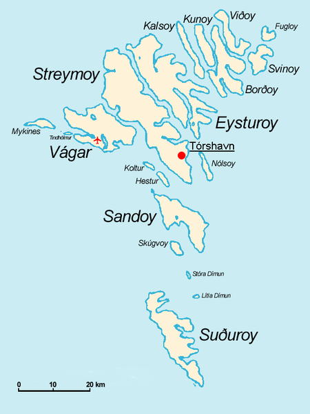
Español: Mapa de las Islas Feroe. Posición del aeropuerto marcado con el avión rojo.
- The Faroe Islands
- Graphics Arne List
- Description: This basic map shows the names of the 18 islands plus the islet Tindhólmur west of Vágar, which is not counted as one of the islands. Furthermore, on this map you see the Airport Vágar and the capital Tórshavn, the two international destinations, if you come via plane or ferry. Last but not least bears the sea no caption, for this map should be translated in different languages by yourself. The sea in the West is the North Atlantic Ocean, and in the East Norwegian Sea (which is a part of the Atlantic).

|
Permission is granted to copy, distribute and/or modify this document under the terms of the GNU Free Documentation License, Version 1.2 or any later version published by the Free Software Foundation; with no Invariant Sections, no Front-Cover Texts, and no Back-Cover Texts. A copy of the license is included in the section entitled GNU Free Documentation License. |
| Tha am faidhle seo fo cheadachas Creative Commons Attribution-Share Alike 3.0 Unported. | ||
| ||
| This licensing tag was added to this file as part of the GFDL licensing update. |
derivative works
Derivative works of this file: Faroe islands map with island names-2.JPG
Eachdraidh an fhaidhle
Briog air ceann-là/àm gus am faidhle a shealltainn mar a nochd e aig an àm sin.
| Ceann-là/Àm | Dealbhag | Meud | Cleachdaiche | Beachd | |
|---|---|---|---|---|---|
| làithreach | 09:32, 18 dhen t-Samhain 2004 | | 600 × 800 (29 KB) | Arne List | GFDL |
Cleachdadh an fhaidhle
Chan eil duilleag sam bith a' ceangal an-seo.
Cleachdadh fhaidhlichean uile-choitcheann
Tha na uicidhean eile a leanas a’ cleachdadh an fhaidhle seo
- Cleachdadh air azb.wikipedia.org
- Cleachdadh air be.wikipedia.org
- Cleachdadh air ca.wikipedia.org
- Cleachdadh air cs.wikipedia.org
- Cleachdadh air da.wikipedia.org
- Cleachdadh air de.wikipedia.org
- Cleachdadh air ee.wikipedia.org
- Cleachdadh air eo.wikipedia.org
- Cleachdadh air eu.wikipedia.org
- Cleachdadh air ext.wikipedia.org
- Cleachdadh air fo.wikipedia.org
- Cleachdadh air fr.wikipedia.org
- Cleachdadh air fr.wiktionary.org
- Cleachdadh air ga.wikipedia.org
- Cleachdadh air gl.wikipedia.org
- Cleachdadh air hu.wikipedia.org
- Cleachdadh air id.wikipedia.org
- Cleachdadh air is.wikipedia.org
- Cleachdadh air mr.wikipedia.org
- Cleachdadh air nl.wikipedia.org
- Cleachdadh air nn.wikipedia.org
- Cleachdadh air no.wikipedia.org
- Cleachdadh air os.wikipedia.org
- Cleachdadh air pl.wikipedia.org
- Cleachdadh air pt.wikipedia.org
- Cleachdadh air ru.wikipedia.org
- Cleachdadh air sh.wikipedia.org
- Cleachdadh air sr.wikipedia.org
- Cleachdadh air sv.wikipedia.org
- Cleachdadh air vi.wikipedia.org
Seall an corr dhen chleachdadh uile-choitcheann a nithear dhen fhaidhle seo.