
Faidhle:East Germany 1956-1990.svg

Size of this PNG preview of this SVG file: 450 × 456 piogsail. Dùmhlachdan-breacaidh eile: 237 × 240 piogsail | 474 × 480 piogsail | 758 × 768 piogsail | 1,011 × 1,024 piogsail | 2,021 × 2,048 piogsail.
Am faidhle tùsail (Faidhle SVG, a-rèir ainm 450 × 456 pixel, meud faidhle: 474 KB)
Gearr-chunntas


.svg)
.svg)
.svg)
.svg)
.svg)


.svg)
.svg)
.svg)


.png)
.png)


.svg)


.svg)

.svg)


.svg)
.svg)
.svg)
.svg)


.svg)
.png)


.svg)


.svg)
.svg)


.svg)


.svg)


.svg)
.svg)
.svg)
.svg)
.svg)
.svg)
.svg)
_cropped.svg)
.svg)
.svg)
.svg)
.svg)
.svg)
.svg)
.svg)
.svg)
.svg)
.svg)
.svg)
.svg)
.svg)
.svg)
.svg)
.svg)
.svg)
.svg)
.svg)
.svg)
.svg)
.svg)
.svg)
.svg)
.svg)
.svg)
.svg)
.svg)
.svg)
.svg)
.svg)
.svg)
.svg)
.svg)
.svg)
.svg)
.svg)
.svg)
.svg)
.svg)
.svg)
.svg)
.svg)
.svg)
.svg)
| This is a retouched picture, which means that it has been digitally altered from its original version. The original can be viewed here: Blank map of Europe 1956-1990.svg:
|
Ceadachadh
I, the copyright holder of this work, hereby publish it under the following license:
Tha am faidhle seo fo cheadachas Creative Commons Attribution-Share Alike 3.0 Unported.
- Faodaidh tu:
- a cho-roinneadh – lethbhreac a dhèanamh dhen obair, a sgaoileadh is a tar-chur
- ath-mheasgachadh – an obair atharrachadh
- Fo bhuaidh nan cumhaichean a leanas:
- urram – Feumaidh tu iomradh a thoirt air an ùghdar no an neach aig a bheil cead air, dìreach mar a thoill iad (ach chan ann air dòigh a chuireas an sùilean dhaoine gu bheil iad ag aontachadh riut no ri d’ obair).
- co-roinneadh co-ionnann – Ma dh’atharraicheas tu no ma leasaicheas tu an obair seo, ’s urrainn an tionndadh ùr fon cheadachas seo no fo cheadachas coltach ris.
Original upload log
This image is a derivative work of the following images:
- File:Blank_map_of_Europe_1956-1990.svg licensed with Cc-by-sa-3.0
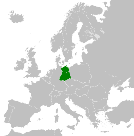
- 2011-10-30T04:43:42Z Alphathon 450x456 (485146 Bytes) == {{int:filedesc}} == {{Information |Description={{en|Blank map of Europe showing national borders as they stood from 1956-1990.}} |Source=*[[:File:Blank_map_of_Europe.svg|]] |Date=2011-10-30 04:42 (UTC) |Author=*[[:File:Bla
Eachdraidh an fhaidhle
Briog air ceann-là/àm gus am faidhle a shealltainn mar a nochd e aig an àm sin.
| Ceann-là/Àm | Dealbhag | Meud | Cleachdaiche | Beachd | |
|---|---|---|---|---|---|
| làithreach | 00:33, 26 dhen t-Samhain 2011 | | 450 × 456 (474 KB) | StalwartUK | == {{int:filedesc}} == {{Information |Description={{en|Map of the East Germany (German Democratic Republic) as it was from 1949-1990. Surrounding countries accurate from 1956-1990.}} |Source=*[[:File:Blank_map_of_Europe_1956-1990.svg| |
Cleachdadh an fhaidhle
Tha ceangal ris an fhaidhle seo san duilleag a leanas:
Cleachdadh fhaidhlichean uile-choitcheann
Tha na uicidhean eile a leanas a’ cleachdadh an fhaidhle seo
- Cleachdadh air af.wikipedia.org
- Cleachdadh air am.wikipedia.org
- Cleachdadh air an.wikipedia.org
- Cleachdadh air ar.wikipedia.org
- Cleachdadh air ast.wikipedia.org
- Cleachdadh air azb.wikipedia.org
- Cleachdadh air az.wikipedia.org
- Cleachdadh air ba.wikipedia.org
- Cleachdadh air be.wikipedia.org
- Cleachdadh air bs.wikipedia.org
- Cleachdadh air ca.wikipedia.org
- Cleachdadh air ce.wikipedia.org
- Cleachdadh air cs.wikipedia.org
- Cleachdadh air de.wikipedia.org
- Cleachdadh air de.wiktionary.org
- Cleachdadh air diq.wikipedia.org
- Cleachdadh air el.wikipedia.org
- Cleachdadh air en.wikipedia.org
- Cleachdadh air en.wiktionary.org
- Cleachdadh air eo.wikipedia.org
- Cleachdadh air es.wikipedia.org
- Cleachdadh air es.wiktionary.org
- Cleachdadh air eu.wikipedia.org
- Cleachdadh air ext.wikipedia.org
- Cleachdadh air fa.wikipedia.org
- Cleachdadh air fi.wikipedia.org
- Cleachdadh air fr.wikipedia.org
- Cleachdadh air fr.wiktionary.org
- Cleachdadh air ga.wikipedia.org
- Cleachdadh air gl.wikipedia.org
- Cleachdadh air gv.wikipedia.org
- Cleachdadh air he.wikipedia.org
- Cleachdadh air hi.wikipedia.org
- Cleachdadh air hr.wikipedia.org
- Cleachdadh air hr.wiktionary.org
- Cleachdadh air hsb.wikipedia.org
- Cleachdadh air hu.wikipedia.org
- Cleachdadh air hy.wikipedia.org
- Cleachdadh air ia.wikipedia.org
- Cleachdadh air id.wikipedia.org
- Cleachdadh air is.wikipedia.org
- Cleachdadh air it.wikipedia.org
- Cleachdadh air ja.wikipedia.org
Seall an corr dhen chleachdadh uile-choitcheann a nithear dhen fhaidhle seo.