
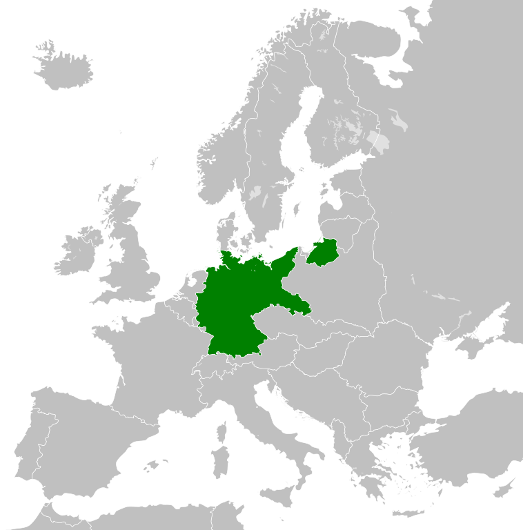
Faidhle:Weimar Republic 1930.svg

Size of this PNG preview of this SVG file: 450 × 456 piogsail. Dùmhlachdan-breacaidh eile: 237 × 240 piogsail | 474 × 480 piogsail | 758 × 768 piogsail | 1,011 × 1,024 piogsail | 2,021 × 2,048 piogsail.
Am faidhle tùsail (Faidhle SVG, a-rèir ainm 450 × 456 pixel, meud faidhle: 483 KB)
Gearr-chunntas


.svg)
.svg)
.svg)
.svg)
.svg)


.svg)
.svg)
.svg)


.png)
.png)


.svg)


.svg)

.svg)


.svg)
.svg)
.svg)
.svg)


.svg)
.png)


.svg)


.svg)
.svg)


.svg)


.svg)


.svg)
.svg)
.svg)
.svg)
.svg)
.svg)
.svg)
_cropped.svg)
.svg)
.svg)
.svg)
.svg)
.svg)
.svg)
.svg)
.svg)
.svg)
.svg)
.svg)
.svg)
.svg)
.svg)
.svg)
.svg)
.svg)
.svg)
.svg)
.svg)
.svg)
.svg)
.svg)
.svg)
.svg)
.svg)
.svg)
.svg)
.svg)
.svg)
.svg)
.svg)
.svg)
.svg)
.svg)
.svg)
.svg)
.svg)
.svg)
.svg)
.svg)
.svg)
.svg)
.svg)
.svg)
Ceadachadh
Tha am faidhle seo fo cheadachas Creative Commons Attribution-Share Alike 3.0 Unported.
- Faodaidh tu:
- a cho-roinneadh – lethbhreac a dhèanamh dhen obair, a sgaoileadh is a tar-chur
- ath-mheasgachadh – an obair atharrachadh
- Fo bhuaidh nan cumhaichean a leanas:
- urram – Feumaidh tu iomradh a thoirt air an ùghdar no an neach aig a bheil cead air, dìreach mar a thoill iad (ach chan ann air dòigh a chuireas an sùilean dhaoine gu bheil iad ag aontachadh riut no ri d’ obair).
- co-roinneadh co-ionnann – Ma dh’atharraicheas tu no ma leasaicheas tu an obair seo, ’s urrainn an tionndadh ùr fon cheadachas seo no fo cheadachas coltach ris.
Original upload log
This image is a derivative work of the following images:
- File:Blank_map_of_Europe.svg licensed with Cc-by-sa-2.5
- 2011-09-19T22:57:58Z Alphathon 680x520 (603759 Bytes) Added North/Northern Cyprus
- 2011-08-23T10:26:48Z Heb 680x520 (604212 Bytes) Added [[:en:Bornholm]] (taken from [[:File:Denmark blank map.svg]])
- 2011-04-12T00:40:40Z Alphathon 680x520 (602549 Bytes) Upgraded Sicily based on "File:Freeworldmaps-sicily.jpg". Upgraded Malta based on "File:Map of Malta 2.png". Simplified Croatian borders.
- 2011-04-10T21:43:04Z Alphathon 680x520 (607359 Bytes) Upgraded Croatia, Bosnia & Herzegovina, Slovenia and surrounding countries based on data from "File:Kroatien - Politische Gliederung (Karte).png"
- 2011-04-10T20:05:09Z Alphathon 680x520 (568373 Bytes) Improved Serbia, Montenegro and surrounding countries using data from "File:Serbia Map.png". Fixed Serbia-Montenegro border. Added Kosovo (using dashed border, since it is not a universally recognised nation, and left the lan
- 2011-04-10T15:55:02Z Alphathon 680x520 (524980 Bytes) Tweaked Ukraine and surrounding countries based on data from "File:Up-map.png"
- 2011-04-10T04:02:09Z Alphathon 680x520 (511168 Bytes) Improved Greece, Albania, F.Y.R. Macedonia and Bulgaria based on "File:Greece topo.jpg"
- 2011-04-10T02:48:52Z Alphathon 680x520 (505569 Bytes) Tweaked Germany and surrounding countries based on info from "File:Germany_general_map.png"
- 2011-04-10T01:54:05Z Alphathon 680x520 (493733 Bytes) Converted all lakes back to separate layer. Added Finish lakes and tweaked Finland shape based on "File:Finland 1996 CIA map.jpg". Added Swiss lakes based on "File:Suisse cantons.svg". Tweaked Scotland and added Lochs.
- 2011-04-10T00:07:54Z Alphathon 680x520 (450120 Bytes) Improved England outline and added Isle of Wight based on "File:England Regions - Blank.svg". Improved Denmark based on "File:2 digit postcode danmark.png". Improved Sweden based on "File:Map of Sweden, CIA, 1996.jpg"
- 2011-04-08T15:53:07Z Alphathon 680x520 (438878 Bytes) Upgraded/fixed various parts of the map. Details: *Some minor fixes to Ireland and added some of the larger lakes based on [[:File:Ireland_trad_counties_named.svg]] *Pretty major fixes to Scotland (mainly the west coast and i
- 2008-09-17T09:50:25Z F7 680x520 (531491 Bytes) '
- 2008-09-17T09:42:57Z F7 680x520 (2353 Bytes) '
- 2008-05-26T19:04:07Z Collard 680x520 (531491 Bytes) uploading on behalf of [[User:Checkit]], direct complaints to him plox: 'Moved countries out of the "outlines" group, removed "outlines" style class, remove separate style information for Russia'
- 2008-04-30T01:38:52Z TimothyBourke 680x520 (531767 Bytes) Changed the country code of Serbia to RS per [http://en.wikipedia.org/wiki/Serbian_country_codes] and the file [http://www.iso.org/iso/iso3166_en_code_lists.txt].
- 2008-02-08T22:44:37Z CarolSpears 680x520 (531767 Bytes) validated
- 2007-07-10T11:47:59Z MrWeeble 680x520 (533112 Bytes) Updated to include British Crown Dependencies as seperate entities and regroup them as "British Islands", with some simplifications to the XML and CSS
- 2007-05-14T17:17:34Z Zirland 680x520 (540659 Bytes) serbia and montenegro
- 2007-03-30T20:40:49Z W!B: 680x520 (538830 Bytes) minor corr: update nl:Ijsselmeer, del fi:lakes (all small), add ru:lake Oneka (all ref maps.google), glued northern irland back to ie ;)
- 2007-02-05T18:44:32Z Maix 680x520 (538295 Bytes) cropped
- 2007-02-04T15:07:29Z Maix 680x520 (538310 Bytes) {{Information |Description=A blank Map of Europe in SVG format. Every country has an id which is its ISO-3116-1-ALPHA2 code in lower case for easy coloring. |Source=Image based on [[Image:Europe_countries.svg|]] by [[User:Ti
Uploaded with derivativeFX
Eachdraidh an fhaidhle
Briog air ceann-là/àm gus am faidhle a shealltainn mar a nochd e aig an àm sin.
| Ceann-là/Àm | Dealbhag | Meud | Cleachdaiche | Beachd | |
|---|---|---|---|---|---|
| làithreach | 03:47, 24 dhen Ghiblean 2018 | | 450 × 456 (483 KB) | TRAJAN 117 | Update |
| 08:00, 12 dhen Lùnastal 2013 |  | 450 × 456 (483 KB) | Alphathon | Fixed Yugoslav-Hungarian border (see main file) | |
| 16:12, 25 dhen Iuchar 2013 |  | 450 × 456 (469 KB) | Alphathon | Removed the Flevoland polders (Netherlands) which were not completed until 1942/1968 | |
| 03:00, 27 dhen Dàmhair 2011 |  | 450 × 456 (469 KB) | Alphathon | Minor tweak | |
| 02:49, 27 dhen Dàmhair 2011 |  | 450 × 456 (469 KB) | Alphathon | Tweaked Romanian borders | |
| 02:30, 27 dhen Dàmhair 2011 |  | 450 × 456 (465 KB) | Alphathon | A few minor fixes (Malta grouped with UK, North Cyprus removed, a few Greek islands moved to Italy per 1930 ownership). | |
| 02:10, 27 dhen Dàmhair 2011 |  | 450 × 456 (466 KB) | Alphathon | == {{int:filedesc}} == {{Information |Description={{en|A Map of the Weimar Republic within Europe circa 1930.}} |Source=*File:Blank_map_of_Europe.svg |Date=2011-10-27 02:10 (UTC) |Author=*File:Blank_map_of_Europe.svg: maix<sup>[[ |
Cleachdadh an fhaidhle
Tha ceangal ris an fhaidhle seo san duilleag a leanas:
Cleachdadh fhaidhlichean uile-choitcheann
Tha na uicidhean eile a leanas a’ cleachdadh an fhaidhle seo
- Cleachdadh air af.wikipedia.org
- Cleachdadh air ar.wikipedia.org
- Cleachdadh air arz.wikipedia.org
- Cleachdadh air ast.wikipedia.org
- Cleachdadh air azb.wikipedia.org
- Cleachdadh air az.wikipedia.org
- Cleachdadh air ba.wikipedia.org
- Cleachdadh air bg.wikipedia.org
- Cleachdadh air bxr.wikipedia.org
- Cleachdadh air ca.wikipedia.org
- Cleachdadh air cs.wikipedia.org
- Cleachdadh air el.wikipedia.org
- Cleachdadh air en.wikipedia.org
- Cleachdadh air es.wikipedia.org
- Cleachdadh air fa.wikipedia.org
- Cleachdadh air fi.wikipedia.org
- Cleachdadh air fr.wikipedia.org
- Cleachdadh air ga.wikipedia.org
- Cleachdadh air gl.wikipedia.org
- Cleachdadh air gv.wikipedia.org
- Cleachdadh air he.wikipedia.org
- Cleachdadh air hi.wikipedia.org
- Cleachdadh air ia.wikipedia.org
- Cleachdadh air id.wikipedia.org
- Cleachdadh air incubator.wikimedia.org
- Cleachdadh air io.wikipedia.org
- Cleachdadh air it.wikipedia.org
- Cleachdadh air ja.wikipedia.org
- Cleachdadh air kk.wikipedia.org
- Cleachdadh air km.wikipedia.org
- Cleachdadh air ko.wikipedia.org
- Cleachdadh air ky.wikipedia.org
- Cleachdadh air lt.wikipedia.org
- Cleachdadh air mg.wikipedia.org
- Cleachdadh air mn.wikipedia.org
- Cleachdadh air mr.wikipedia.org
- Cleachdadh air ms.wikipedia.org
- Cleachdadh air pap.wikipedia.org
- Cleachdadh air pl.wikipedia.org
Seall an corr dhen chleachdadh uile-choitcheann a nithear dhen fhaidhle seo.