
Faidhle:Topographic map of Åland.svg

Size of this PNG preview of this SVG file: 681 × 516 piogsail. Dùmhlachdan-breacaidh eile: 317 × 240 piogsail | 634 × 480 piogsail | 1,014 × 768 piogsail | 1,280 × 970 piogsail | 2,560 × 1,940 piogsail.
Am faidhle tùsail (Faidhle SVG, a-rèir ainm 681 × 516 pixel, meud faidhle: 172 KB)
Gearr-chunntas
This W3C-unspecified vector image was created with Inkscape .
| Tuairisgeul |
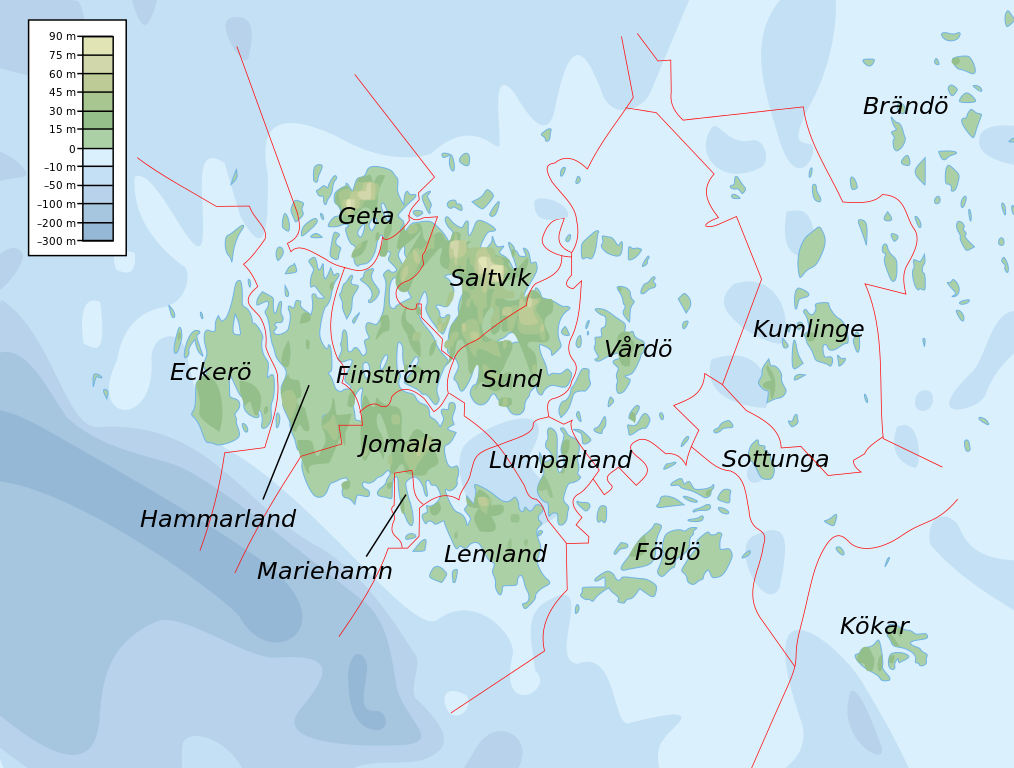
English: Topographic map of the Åland Islands.
Français : Carte topographique des îles d'Åland.
Suomi: Ahvenanmaan topografinen kartta.
Approximate limits:
|
| Ceann-là | |
| Tùs |
Self-made in Inkscape. Boundaries and municipality borders based on Image:Alandmunicipalities.png. Topography based on public domain GLOBE data from NOAA (http://www.ngdc.noaa.gov/mgg/topo/gltiles.html). Bathymetry adapted after a small slice from T. Seifert, F. Tauber, B. Kayser: 2001: "A high resolution spherical grid topography of the Baltic Sea – 2nd edition", Baltic Sea Science Congress, Stockholm 25-29. November 2001, Poster #147, www.io-warnemuende.de/iowtopo. Colors and overall look based on maps by User:Bamse. |
| Ùghdar | Mysid |
| Other versions | Derivative works of this file: Aland EU.svg |

|
This SVG file contains embedded text that can be translated into your language, using any capable SVG editor, text editor or the SVG Translate tool. For more information see: About translating SVG files. |
Ceadachadh
I, the copyright holder of this work, hereby publish it under the following licenses:

|
Permission is granted to copy, distribute and/or modify this document under the terms of the GNU Free Documentation License, Version 1.2 or any later version published by the Free Software Foundation; with no Invariant Sections, no Front-Cover Texts, and no Back-Cover Texts. A copy of the license is included in the section entitled GNU Free Documentation License. |
This file is licensed under the Creative Commons Attribution-Share Alike 4.0 International, 3.0 Unported, 2.5 Generic, 2.0 Generic and 1.0 Generic license.
- Faodaidh tu:
- a cho-roinneadh – lethbhreac a dhèanamh dhen obair, a sgaoileadh is a tar-chur
- ath-mheasgachadh – an obair atharrachadh
- Fo bhuaidh nan cumhaichean a leanas:
- urram – Feumaidh tu iomradh a thoirt air an ùghdar no an neach aig a bheil cead air, dìreach mar a thoill iad (ach chan ann air dòigh a chuireas an sùilean dhaoine gu bheil iad ag aontachadh riut no ri d’ obair).
- co-roinneadh co-ionnann – Ma dh’atharraicheas tu no ma leasaicheas tu an obair seo, ’s urrainn an tionndadh ùr fon cheadachas seo no fo cheadachas coltach ris.
’S urrainn dhut an ceadachas as fhearr leat a thaghadh.
Eachdraidh an fhaidhle
Briog air ceann-là/àm gus am faidhle a shealltainn mar a nochd e aig an àm sin.
| Ceann-là/Àm | Dealbhag | Meud | Cleachdaiche | Beachd | |
|---|---|---|---|---|---|
| làithreach | 11:06, 12 dhen Ghearran 2008 | | 681 × 516 (172 KB) | Mysid | border wouldn't work |
| 11:05, 12 dhen Ghearran 2008 |  | 681 × 516 (172 KB) | Mysid | {{inkscape}} {{Information |Description={{en|Topographic map of the Åland Islands.}} {{fi|Ahvenanmaan topografinen kartta.}} |Source=Self-made in Inkscape.<br/>Boundaries and municipality borders based on [[:Imag |
Cleachdadh an fhaidhle
Tha ceangal ris an fhaidhle seo san duilleag a leanas:
Cleachdadh fhaidhlichean uile-choitcheann
Tha na uicidhean eile a leanas a’ cleachdadh an fhaidhle seo
- Cleachdadh air ar.wikipedia.org
- Cleachdadh air az.wiktionary.org
- Cleachdadh air ba.wikipedia.org
- Cleachdadh air be.wikipedia.org
- Cleachdadh air bs.wikipedia.org
- Cleachdadh air de.wikipedia.org
- Cleachdadh air en.wikipedia.org
- Cleachdadh air et.wikipedia.org
- Cleachdadh air fi.wikipedia.org
- Cleachdadh air fo.wikipedia.org
- Cleachdadh air fr.wikipedia.org
- Cleachdadh air fy.wikipedia.org
- Cleachdadh air he.wikipedia.org
- Cleachdadh air is.wikipedia.org
- Cleachdadh air kk.wikipedia.org
- Cleachdadh air ky.wikipedia.org
- Cleachdadh air lb.wikipedia.org
- Cleachdadh air mi.wikipedia.org
- Cleachdadh air no.wikipedia.org
- Cleachdadh air os.wikipedia.org
- Cleachdadh air rue.wikipedia.org
- Cleachdadh air ru.wikipedia.org
- Cleachdadh air simple.wiktionary.org
- Cleachdadh air sv.wikipedia.org
- Cleachdadh air uk.wikipedia.org
- Cleachdadh air zh.wikipedia.org