
Faidhle:The summit of Carn Ghluasaid - geograph.org.uk - 775383.jpg

Meud an ro-sheallaidh seo: 800 × 544 piogsail. Dùmhlachdan-breacaidh eile: 320 × 218 piogsail | 640 × 435 piogsail | 1,024 × 696 piogsail.
Am faidhle tùsail (1,024 × 696 pixel, meud an fhaidhle: 1.17 MB, seòrsa MIME: image/jpeg)
Gearr-chunntas
| Tuairisgeul |
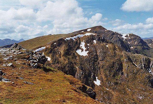
English: The summit of Carn Ghluasaid The cairn on the left appears to mark the summit, and corresponds to the 1:25000 map; the 1:50000 map seems a bit inaccurate here. Beyond lies the great eastern face of Creag a' Chaorainn, with Sgurr nan Conbhairean in the distance. |
| Ceann-là | |
| Tùs | From geograph.org.uk |
| Ùghdar | Nigel Brown |
| Urram (required by the license) | Nigel Brown / The summit of Carn Ghluasaid / |
| Camera location | | View this and other nearby images on: OpenStreetMap |
|---|
_heading:292.00&language=gd)
| Object location | | View this and other nearby images on: OpenStreetMap |
|---|
_heading:292.00&language=gd)
Ceadachadh

|
This image was taken from the Geograph project collection. See this photograph's page on the Geograph website for the photographer's contact details. The copyright on this image is owned by Nigel Brown and is licensed for reuse under the Creative Commons Attribution-ShareAlike 2.0 license.
|
This file is licensed under the Creative Commons Attribution-Share Alike 2.0 Generic license.
Urram: Nigel Brown
- Faodaidh tu:
- a cho-roinneadh – lethbhreac a dhèanamh dhen obair, a sgaoileadh is a tar-chur
- ath-mheasgachadh – an obair atharrachadh
- Fo bhuaidh nan cumhaichean a leanas:
- urram – Feumaidh tu iomradh a thoirt air an ùghdar no an neach aig a bheil cead air, dìreach mar a thoill iad (ach chan ann air dòigh a chuireas an sùilean dhaoine gu bheil iad ag aontachadh riut no ri d’ obair).
- co-roinneadh co-ionnann – Ma dh’atharraicheas tu no ma leasaicheas tu an obair seo, ’s urrainn an tionndadh ùr fon cheadachas seo no fo cheadachas coltach ris.
Eachdraidh an fhaidhle
Briog air ceann-là/àm gus am faidhle a shealltainn mar a nochd e aig an àm sin.
| Ceann-là/Àm | Dealbhag | Meud | Cleachdaiche | Beachd | |
|---|---|---|---|---|---|
| làithreach | 16:10, 16 dhen Chèitean 2020 | | 1,024 × 696 (1.17 MB) | Geograph Update Bot | Higher-resolution version from Geograph. |
| 23:27, 19 dhen Ghearran 2011 |  | 640 × 435 (113 KB) | GeographBot | == {{int:filedesc}} == {{Information |description={{en|1=The summit of Carn Ghluasaid The cairn on the left appears to mark the summit, and corresponds to the 1:25000 map; the 1:50000 map seems a bit inaccurate here. Beyond lies the great eastern face of |
Cleachdadh an fhaidhle
Tha ceangal ris an fhaidhle seo san duilleag a leanas:
Cleachdadh fhaidhlichean uile-choitcheann
Tha na uicidhean eile a leanas a’ cleachdadh an fhaidhle seo
- Cleachdadh air ceb.wikipedia.org
- Cleachdadh air cy.wikipedia.org
- Cleachdadh air de.wikipedia.org
- Cleachdadh air lld.wikipedia.org
- Cleachdadh air www.wikidata.org