
Faidhle:St Peters Church, Pentre, Rhondda Fawr Valley, South Wales - geograph.org.uk - 1248615.jpg

Meud an ro-sheallaidh seo: 495 × 599 piogsail. Dùmhlachdan-breacaidh eile: 198 × 240 piogsail | 529 × 640 piogsail.
Am faidhle tùsail (529 × 640 pixel, meud an fhaidhle: 144 KB, seòrsa MIME: image/jpeg)
Gearr-chunntas
| Tuairisgeul |
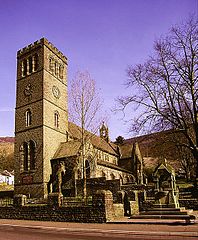
English: St Peters Church, Pentre, Rhondda Fawr Valley, South Wales Built in 1890 at the height of the coal boom time in the Rhondda Valley.
St Peter's has a magnificent peal of 8 bells with the tenor a heavy 1,366kg. The tower is over 100ft high. |
| Ceann-là | |
| Tùs | From geograph.org.uk |
| Ùghdar | Peter Brabham |
| Urram (required by the license) | Peter Brabham / St Peters Church, Pentre, Rhondda Fawr Valley, South Wales / |
| Camera location | | View this and other nearby images on: OpenStreetMap |
|---|
_heading:337.00&language=gd)
| Object location | | View this and other nearby images on: OpenStreetMap |
|---|
_heading:337.00&language=gd)
Ceadachadh

|
This image was taken from the Geograph project collection. See this photograph's page on the Geograph website for the photographer's contact details. The copyright on this image is owned by Peter Brabham and is licensed for reuse under the Creative Commons Attribution-ShareAlike 2.0 license.
|
This file is licensed under the Creative Commons Attribution-Share Alike 2.0 Generic license.
Urram: Peter Brabham
- Faodaidh tu:
- a cho-roinneadh – lethbhreac a dhèanamh dhen obair, a sgaoileadh is a tar-chur
- ath-mheasgachadh – an obair atharrachadh
- Fo bhuaidh nan cumhaichean a leanas:
- urram – Feumaidh tu iomradh a thoirt air an ùghdar no an neach aig a bheil cead air, dìreach mar a thoill iad (ach chan ann air dòigh a chuireas an sùilean dhaoine gu bheil iad ag aontachadh riut no ri d’ obair).
- co-roinneadh co-ionnann – Ma dh’atharraicheas tu no ma leasaicheas tu an obair seo, ’s urrainn an tionndadh ùr fon cheadachas seo no fo cheadachas coltach ris.
| Annotations | This image is annotated: View the annotations at Commons |
Eachdraidh an fhaidhle
Briog air ceann-là/àm gus am faidhle a shealltainn mar a nochd e aig an àm sin.
| Ceann-là/Àm | Dealbhag | Meud | Cleachdaiche | Beachd | |
|---|---|---|---|---|---|
| làithreach | 17:46, 26 dhen Ghearran 2011 | | 529 × 640 (144 KB) | GeographBot | == {{int:filedesc}} == {{Information |description={{en|1=St Peters Church, Pentre, Rhondda Fawr Valley, South Wales Built in 1890 at the height of the coal boom time in the Rhondda Valley. St Peter's has a magnificent peal of 8 bells with the tenor a hea |
Cleachdadh an fhaidhle
Tha ceangal ris an fhaidhle seo san duilleag a leanas:
Cleachdadh fhaidhlichean uile-choitcheann
Tha na uicidhean eile a leanas a’ cleachdadh an fhaidhle seo
- Cleachdadh air cy.wikipedia.org
- Cleachdadh air de.wikipedia.org
- Cleachdadh air en.wikipedia.org
- Cleachdadh air eu.wikipedia.org
- Cleachdadh air fr.wikipedia.org
- Cleachdadh air ga.wikipedia.org
- Cleachdadh air kw.wikipedia.org
- Cleachdadh air sv.wikipedia.org
- Cleachdadh air www.wikidata.org
- Cleachdadh air zh-min-nan.wikipedia.org