
Faidhle:Scotland topographic map-en.jpg
Meud an ro-sheallaidh seo: 417 × 599 piogsail. Dùmhlachdan-breacaidh eile: 167 × 240 piogsail | 334 × 480 piogsail | 534 × 768 piogsail | 712 × 1,024 piogsail | 2,400 × 3,450 piogsail.
Am faidhle tùsail (2,400 × 3,450 pixel, meud an fhaidhle: 2.29 MB, seòrsa MIME: image/jpeg)
Gearr-chunntas
| Camera location | | View this and other nearby images on: OpenStreetMap |
|---|
| Tuairisgeul |
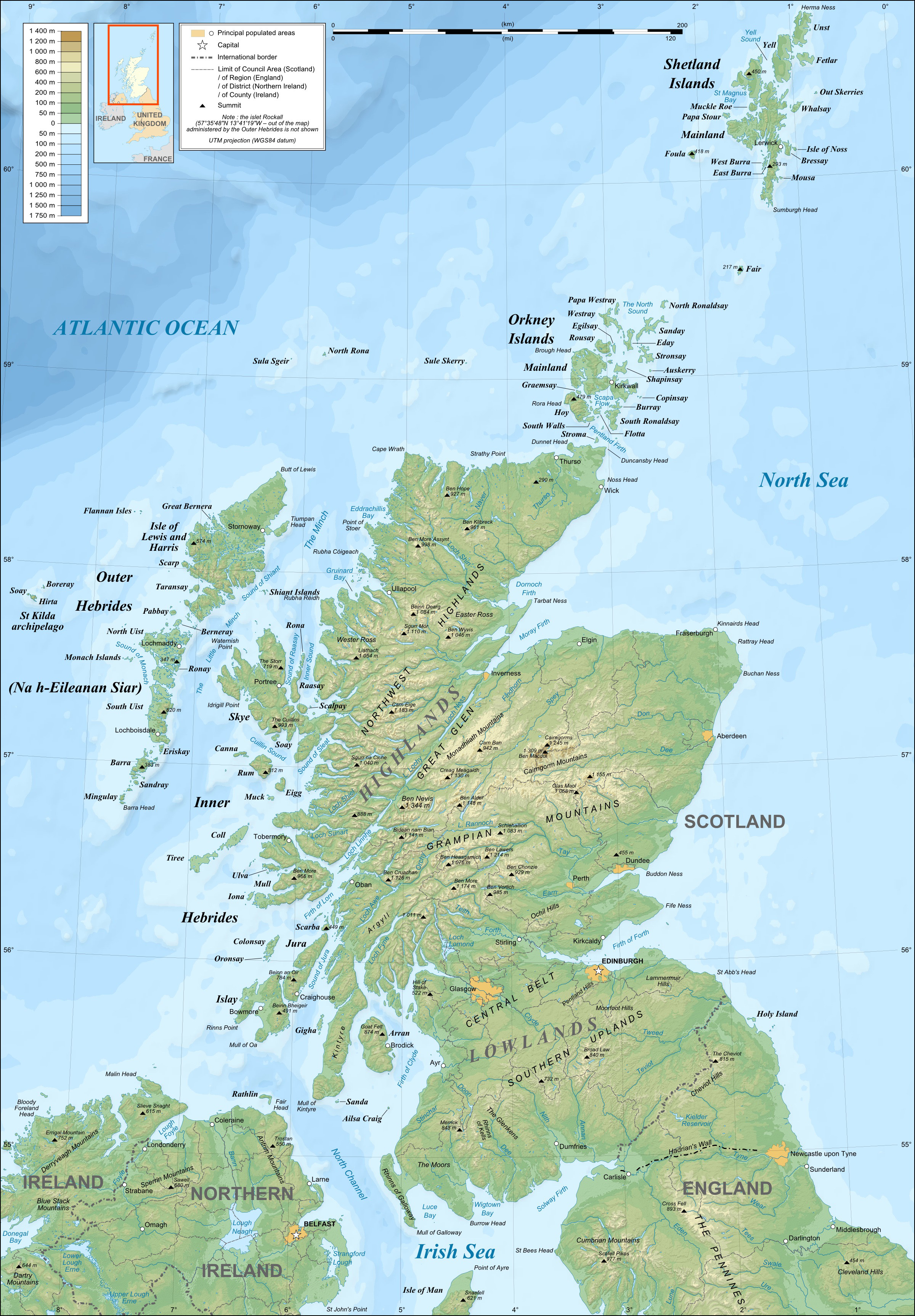
English: Topographic map in English of Scotland
This is a lighter raster JPG format version of Image:Scotland_topographic_map-en.svg which should be used in the article pages, the vector graphics version purpose being for modification and / or translation. Français : Carte topographique en anglais de l'Écosse.
Ceci est une version bitmap au format JPG et de poids de fichier plus léger de Image:Scotland_topographic_map-fr.svg qui devrait être utilisée dans les pages d'articles, la version vectorisée SVG étant destinée à faciliter les modifications et / ou traductions.
|
||
| Ceann-là | December 2007 (modified 09-2008) | ||
| Tùs |
Own work ;
|
||
| Ùghdar | Eric Gaba (Sting – fr:Sting) | ||
| Cead (Ag ath-chleachdadh an fhaidhle seo) |
|
||
| Other versions |
Derivative works of this file: River Forth course 3.png
[]
|


Ceadachadh
I, the copyright holder of this work, hereby publish it under the following licenses:

|
Permission is granted to copy, distribute and/or modify this document under the terms of the GNU Free Documentation License, Version 1.2 or any later version published by the Free Software Foundation; with no Invariant Sections, no Front-Cover Texts, and no Back-Cover Texts. A copy of the license is included in the section entitled GNU Free Documentation License. |
This file is licensed under the Creative Commons Attribution-Share Alike 4.0 International, 3.0 Unported, 2.5 Generic, 2.0 Generic and 1.0 Generic license.
- Faodaidh tu:
- a cho-roinneadh – lethbhreac a dhèanamh dhen obair, a sgaoileadh is a tar-chur
- ath-mheasgachadh – an obair atharrachadh
- Fo bhuaidh nan cumhaichean a leanas:
- urram – Feumaidh tu iomradh a thoirt air an ùghdar no an neach aig a bheil cead air, dìreach mar a thoill iad (ach chan ann air dòigh a chuireas an sùilean dhaoine gu bheil iad ag aontachadh riut no ri d’ obair).
- co-roinneadh co-ionnann – Ma dh’atharraicheas tu no ma leasaicheas tu an obair seo, ’s urrainn an tionndadh ùr fon cheadachas seo no fo cheadachas coltach ris.
’S urrainn dhut an ceadachas as fhearr leat a thaghadh.
Eachdraidh an fhaidhle
Briog air ceann-là/àm gus am faidhle a shealltainn mar a nochd e aig an àm sin.
| Ceann-là/Àm | Dealbhag | Meud | Cleachdaiche | Beachd | |
|---|---|---|---|---|---|
| làithreach | 21:41, 17 dhen Iuchar 2010 | | 2,400 × 3,450 (2.29 MB) | Sting | Color profile |
| 23:35, 24 dhen t-Sultain 2008 |  | 2,400 × 3,450 (1.99 MB) | Sting | Completely new background : raster topography and using ETOPO1 data for bathymetry ; new standard colors | |
| 01:02, 14 dhen Dùbhlachd 2007 |  | 2,400 × 3,450 (2.12 MB) | Sting | Additional name | |
| 20:55, 12 dhen Dùbhlachd 2007 |  | 2,400 × 3,450 (2.12 MB) | Sting | Correction in key | |
| 16:18, 12 dhen Dùbhlachd 2007 |  | 2,400 × 3,450 (2.12 MB) | Sting | {{Location|57|00|00|N|04|00|00|W|scale:4000000}} <br/> {{Information |Description=Topographic map in English of Scotland<br/>This is a lighter raster JPG format version of Image:Scotland_topographic_map-en.svg which should be used in |
Cleachdadh an fhaidhle
Tha ceangal ris an fhaidhle seo san duilleag a leanas:
Cleachdadh fhaidhlichean uile-choitcheann
Tha na uicidhean eile a leanas a’ cleachdadh an fhaidhle seo
- Cleachdadh air en.wikipedia.org
- Cleachdadh air es.wikipedia.org
- Cleachdadh air ga.wiktionary.org
- Cleachdadh air hu.wikipedia.org
- Cleachdadh air id.wikipedia.org
- Cleachdadh air lt.wikipedia.org
- Cleachdadh air so.wikipedia.org
- Cleachdadh air to.wikipedia.org
- Cleachdadh air uk.wikipedia.org