
Faidhle:Rheinbund 1812, political map.png

Meud an ro-sheallaidh seo: 525 × 600 piogsail. Dùmhlachdan-breacaidh eile: 210 × 240 piogsail | 420 × 480 piogsail | 672 × 768 piogsail | 896 × 1,024 piogsail | 2,067 × 2,362 piogsail.
Am faidhle tùsail (2,067 × 2,362 pixel, meud an fhaidhle: 1.09 MB, seòrsa MIME: image/png)
Gearr-chunntas
| Tuairisgeul |
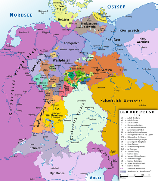
Deutsch: Karte des Rheinbundes 1812
English: Map of Confederation of the Rhine 1812 |
||||||||
| Ceann-là | |||||||||
| Tùs | M’ obair fhèin drawing/Source of Information: Putzger – Historischer Weltatlas, 89. Auflage, 1965; Westermanns Großer Atlas zuur Weltgeschichte, 1969; Haacks geographischer Atlas. VEB Hermann Haack Geographisch-Kartographische Anstalt, Gotha/Leipzig, 1. Auflage, 1979. | ||||||||
| Ùghdar | ziegelbrenner | ||||||||
| Cead (Ag ath-chleachdadh an fhaidhle seo) |
I, the copyright holder of this work, hereby publish it under the following licenses:
This file is licensed under the Creative Commons Attribution 2.5 Generic license.
’S urrainn dhut an ceadachas as fhearr leat a thaghadh. |


|
This historical map image could be re-created using vector graphics as an SVG file. This has several advantages; see Commons:Media for cleanup for more information. If an SVG form of this image is available, please upload it and afterwards replace this template with
{{vector version available|new image name}}.
It is recommended to name the SVG file “Rheinbund 1812, political map.svg”—then the template Vector version available (or Vva) does not need the new image name parameter. |
Eachdraidh an fhaidhle
Briog air ceann-là/àm gus am faidhle a shealltainn mar a nochd e aig an àm sin.
| Ceann-là/Àm | Dealbhag | Meud | Cleachdaiche | Beachd | |
|---|---|---|---|---|---|
| làithreach | 11:49, 14 dhen Ghearran 2014 | | 2,067 × 2,362 (1.09 MB) | Ziegelbrenner | 2014-02-14 |
| 10:33, 3 dhen Ghearran 2014 |  | 2,068 × 2,362 (1.89 MB) | Ziegelbrenner | 2014-02-03 | |
| 13:28, 31 dhen Fhaoilleach 2014 |  | 525 × 600 (182 KB) | Ziegelbrenner | Reverted to version as of 14:58, 21 January 2014 Why did you revert this? New version has some corrections. | |
| 16:14, 30 dhen Fhaoilleach 2014 |  | 2,008 × 2,362 (1.72 MB) | Эрманарих | Reverted to version as of 15:13, 3 February 2011 | |
| 14:58, 21 dhen Fhaoilleach 2014 |  | 525 × 600 (182 KB) | Ziegelbrenner | Some borders corrected | |
| 15:13, 3 dhen Ghearran 2011 |  | 2,008 × 2,362 (1.72 MB) | Ziegelbrenner | 2011-02-03 | |
| 15:08, 3 dhen Ghearran 2011 |  | 2,008 × 2,362 (1.72 MB) | Ziegelbrenner | 2011-02-03 | |
| 14:56, 3 dhen Ghearran 2011 |  | 2,067 × 2,362 (1.76 MB) | Ziegelbrenner | 2011-02-03 | |
| 10:43, 3 dhen Ghearran 2011 |  | 2,008 × 2,362 (3.49 MB) | Ziegelbrenner | 2011-02-03 | |
| 18:04, 30 dhen Chèitean 2010 |  | 2,067 × 2,362 (2.44 MB) | Max96 | Edited out the purple "blob" in Thuringia |
Cleachdadh an fhaidhle
Tha ceangal ris an fhaidhle seo sna duilleagan a leanas:
Cleachdadh fhaidhlichean uile-choitcheann
Tha na uicidhean eile a leanas a’ cleachdadh an fhaidhle seo
- Cleachdadh air an.wikipedia.org
- Cleachdadh air ar.wikipedia.org
- Cleachdadh air ast.wikipedia.org
- Cleachdadh air azb.wikipedia.org
- Cleachdadh air be.wikipedia.org
- Cleachdadh air br.wikipedia.org
- Cleachdadh air ca.wikipedia.org
- Liechtenstein
- Waldeck
- Confederació del Rin
- Ducat de Nassau
- Plantilla:Estats de la Confederació del Rin
- Gran Ducat de Berg
- Comtat d'Arenberg
- Hohenzollern-Sigmaringen
- Regne de Saxònia
- Regne de Westfàlia
- Regne de Baviera
- Gran ducat de Hessen i del Rin
- Regne de Württemberg
- Gran Ducat de Baden
- Anhalt
- Anhalt-Bernburg
- Anhalt-Dessau
- Anhalt-Köthen
- Saxònia-Weimar-Eisenach
- Saxònia-Eisenach
- Reuss-Ebersdorf
- Reuss-Lobenstein
- Schaumburg-Lippe
- Principat de Lippe
- Ducat de Mecklenburg-Schwerin
- Cleachdadh air cs.wikipedia.org
- Cleachdadh air cv.wikipedia.org
- Cleachdadh air da.wikipedia.org
Seall an corr dhen chleachdadh uile-choitcheann a nithear dhen fhaidhle seo.