
Faidhle:Map of Scotland within the United Kingdom.svg

Size of this PNG preview of this SVG file: 387 × 600 piogsail. Dùmhlachdan-breacaidh eile: 155 × 240 piogsail | 309 × 480 piogsail | 495 × 768 piogsail | 660 × 1,024 piogsail | 1,321 × 2,048 piogsail | 616 × 955 piogsail.
Am faidhle tùsail (Faidhle SVG, a-rèir ainm 616 × 955 pixel, meud faidhle: 125 KB)
Gearr-chunntas
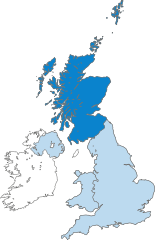
| Tuairisgeul | Map of Scotland (dark blue) within the United Kingdom. |
| Ceann-là | (UTC) |
| Tùs |
This file was derived from: United Kingdom in the British Isles.svg: |
| Ùghdar | Peeperman |
| Other versions |
|
| SVG genesis | This locator map was created with Adobe Illustrator. |
Ceadachadh
I, the copyright holder of this work, hereby publish it under the following licenses:
| Tha am faidhle seo fo cheadachas Creative Commons Attribution-Share Alike 3.0 Unported. | ||
| ||
| This licensing tag was added to this file as part of the GFDL licensing update. |

|
Permission is granted to copy, distribute and/or modify this document under the terms of the GNU Free Documentation License, Version 1.2 or any later version published by the Free Software Foundation; with no Invariant Sections, no Front-Cover Texts, and no Back-Cover Texts. A copy of the license is included in the section entitled GNU Free Documentation License. |
’S urrainn dhut an ceadachas as fhearr leat a thaghadh.
Eachdraidh an fhaidhle
Briog air ceann-là/àm gus am faidhle a shealltainn mar a nochd e aig an àm sin.
| Ceann-là/Àm | Dealbhag | Meud | Cleachdaiche | Beachd | |
|---|---|---|---|---|---|
| làithreach | 18:27, 27 dhen Lùnastal 2012 | | 616 × 955 (125 KB) | Peeperman | minor edit |
| 18:17, 27 dhen Lùnastal 2012 |  | 616 × 955 (125 KB) | Peeperman | {{Information |Description=Map of Scotland (dark blue) within the United Kingdom. |Source={{Derived from|British Isles United Kingdom.svg|display=50}} |Date=2012-06-14 19:17 (UTC) |Author=Peeperman |Permission= |other_versions=[[File... |
Cleachdadh an fhaidhle
Tha ceangal ris an fhaidhle seo san duilleag a leanas:
Cleachdadh fhaidhlichean uile-choitcheann
Tha na uicidhean eile a leanas a’ cleachdadh an fhaidhle seo
- Cleachdadh air an.wikipedia.org
- Cleachdadh air ar.wikipedia.org
- Cleachdadh air ast.wikipedia.org
- Cleachdadh air de.wikipedia.org
- Cleachdadh air de.wiktionary.org
- Cleachdadh air el.wiktionary.org
- Cleachdadh air en.wikipedia.org
- Cleachdadh air es.wikipedia.org
- Cleachdadh air fr.wikipedia.org
- Cleachdadh air gl.wikipedia.org
- Cleachdadh air gv.wikipedia.org
- Cleachdadh air ht.wikipedia.org
- Cleachdadh air id.wikipedia.org
- Cleachdadh air incubator.wikimedia.org
- Cleachdadh air it.wikipedia.org
- Cleachdadh air it.wikinews.org
- Cleachdadh air it.wiktionary.org
- Cleachdadh air pt.wikipedia.org
- Cleachdadh air sr.wikipedia.org
- Cleachdadh air sv.wikipedia.org
- Cleachdadh air uk.wikipedia.org
- Cleachdadh air zh.wikipedia.org