
Faidhle:EH postcode area map.svg

Size of this PNG preview of this SVG file: 800 × 560 piogsail. Dùmhlachdan-breacaidh eile: 320 × 224 piogsail | 640 × 448 piogsail | 1,024 × 717 piogsail | 1,280 × 896 piogsail | 2,560 × 1,792 piogsail | 1,000 × 700 piogsail.
Am faidhle tùsail (Faidhle SVG, a-rèir ainm 1,000 × 700 pixel, meud faidhle: 560 KB)
W3C-validity not checked.
Gearr-chunntas
| Tuairisgeul |
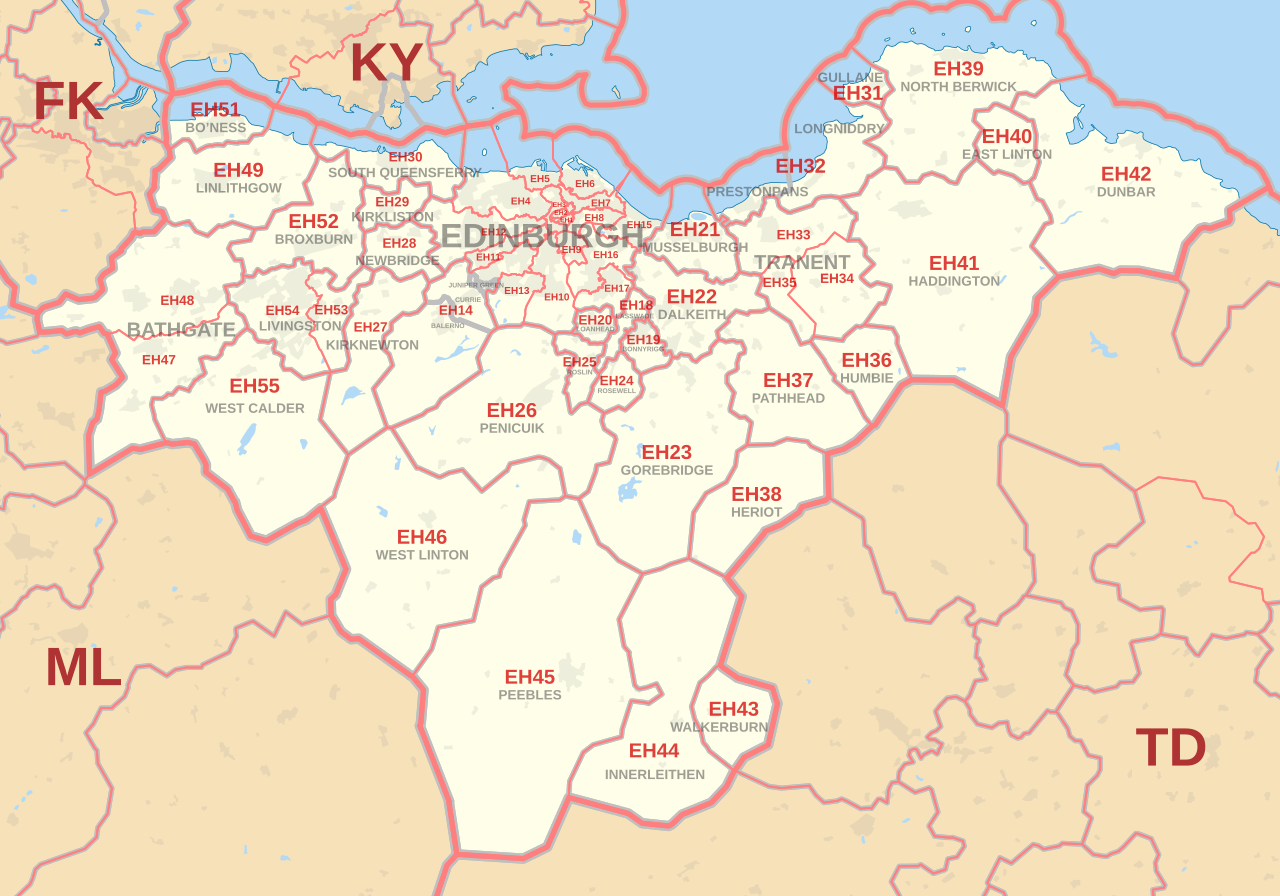
English: Labelled map of Royal Mail postcode districts of the EH postcode area.
Indicative postcode districts shown in red, post towns shown in grey. Equirectangular projection with latitude stretching 180%, WGS84 datum. Geographic limits:
|
| Ceann-là | |
| Tùs |
Derived from Ordnance Survey OS OpenData.
|
| Ùghdar | Richardguk |
| Camera location | | View this and other nearby images on: OpenStreetMap |
|---|
See also 
|
Ceadachadh
I, the copyright holder of this work, hereby publish it under the following license:
Tha am faidhle seo fo cheadachas Creative Commons Attribution-Share Alike 3.0 Unported.
- Faodaidh tu:
- a cho-roinneadh – lethbhreac a dhèanamh dhen obair, a sgaoileadh is a tar-chur
- ath-mheasgachadh – an obair atharrachadh
- Fo bhuaidh nan cumhaichean a leanas:
- urram – Feumaidh tu iomradh a thoirt air an ùghdar no an neach aig a bheil cead air, dìreach mar a thoill iad (ach chan ann air dòigh a chuireas an sùilean dhaoine gu bheil iad ag aontachadh riut no ri d’ obair).
- co-roinneadh co-ionnann – Ma dh’atharraicheas tu no ma leasaicheas tu an obair seo, ’s urrainn an tionndadh ùr fon cheadachas seo no fo cheadachas coltach ris.
This file is licensed by the Ordnance Survey of the United Kingdom under their OS OpenData License
In short: you are free to distribute and modify the file as long as you attribute (including year), the Ordnance Survey and Royal Mail. Urram: Contains Ordnance Survey and Royal Mail data © Crown copyright and database right (year) Note: Derivative works can be licensed under any Creative Commons Attribution 3.0 Licence. |
.svg)
|
This file is licensed under the United Kingdom Open Government Licence v3.0. |
See also: Meta for information on usage on Wikimedia wikis.
|
Eachdraidh an fhaidhle
Briog air ceann-là/àm gus am faidhle a shealltainn mar a nochd e aig an àm sin.
| Ceann-là/Àm | Dealbhag | Meud | Cleachdaiche | Beachd | |
|---|---|---|---|---|---|
| làithreach | 11:36, 16 dhen Dàmhair 2012 | | 1,000 × 700 (560 KB) | Richardguk | revised styling for EH postcode area map |
| 12:24, 10 dhen Dàmhair 2012 |  | 1,000 × 700 (541 KB) | Richardguk | User created page with UploadWizard |
Cleachdadh an fhaidhle
Tha ceangal ris an fhaidhle seo san duilleag a leanas:
Cleachdadh fhaidhlichean uile-choitcheann
Tha na uicidhean eile a leanas a’ cleachdadh an fhaidhle seo
- Cleachdadh air en.wikipedia.org
- Cleachdadh air fr.wikipedia.org
- Cleachdadh air it.wikipedia.org