
Faidhle:Clark County Nevada Incorporated Areas Henderson highlighted.svg

Size of this PNG preview of this SVG file: 538 × 599 piogsail. Dùmhlachdan-breacaidh eile: 215 × 240 piogsail | 431 × 480 piogsail | 689 × 768 piogsail | 919 × 1,024 piogsail | 1,838 × 2,048 piogsail | 700 × 780 piogsail.
Am faidhle tùsail (Faidhle SVG, a-rèir ainm 700 × 780 pixel, meud faidhle: 139 KB)
Gearr-chunntas
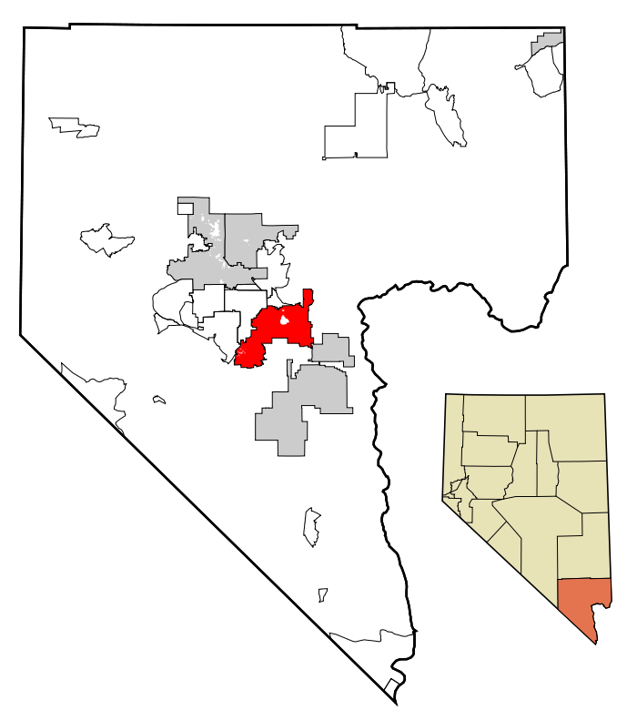
| Tuairisgeul | This map shows the incorporated areas in Clark County, Nevada. Henderson is highlighted in red. I created it in Inkscape using data from the following files: Census 2000 Block Map - Clark County (PDF) and Southern Nevada Public Lands Management Act Map (PDF) |
| Ceann-là | |
| Tùs | My own work, based on government information. Though I strove to be as accurate in the detail as possible, the information shown is not guaranteed to be completely accurate. |
| Ùghdar | Ixnayonthetimmay |
| Cead (Ag ath-chleachdadh an fhaidhle seo) |
Public Domain |
| Other versions | See Category:Maps of Clark County, Nevada for other versions of this image. |
Ceadachadh
| I, the copyright holder of this work, release this work into the public domain. This applies worldwide. In some countries this may not be legally possible; if so: I grant anyone the right to use this work for any purpose, without any conditions, unless such conditions are required by law. |
Eachdraidh an fhaidhle
Briog air ceann-là/àm gus am faidhle a shealltainn mar a nochd e aig an àm sin.
| Ceann-là/Àm | Dealbhag | Meud | Cleachdaiche | Beachd | |
|---|---|---|---|---|---|
| làithreach | 01:08, 18 dhen Iuchar 2007 | | 700 × 780 (139 KB) | Ixnayonthetimmay | == Summary == {{Information |Description=This map shows the incorporated areas in Clark County, Nevada. Henderson is highlighted in red. I created it in [[en:Inksca |
Cleachdadh an fhaidhle
Tha ceangal ris an fhaidhle seo san duilleag a leanas:
Cleachdadh fhaidhlichean uile-choitcheann
Tha na uicidhean eile a leanas a’ cleachdadh an fhaidhle seo
- Cleachdadh air ang.wikipedia.org
- Cleachdadh air ar.wikipedia.org
- Cleachdadh air arz.wikipedia.org
- Cleachdadh air azb.wikipedia.org
- Cleachdadh air br.wikipedia.org
- Cleachdadh air ca.wikipedia.org
- Cleachdadh air ceb.wikipedia.org
- Cleachdadh air de.wikipedia.org
- Cleachdadh air el.wikipedia.org
- Cleachdadh air en.wikipedia.org
- Cleachdadh air eo.wikipedia.org
- Cleachdadh air eu.wikipedia.org
- Cleachdadh air fa.wikipedia.org
- Cleachdadh air fi.wikipedia.org
- Cleachdadh air fr.wikipedia.org
- Cleachdadh air ga.wikipedia.org
- Cleachdadh air gl.wikipedia.org
- Cleachdadh air he.wikipedia.org
- Cleachdadh air ht.wikipedia.org
- Cleachdadh air id.wikipedia.org
- Cleachdadh air it.wikipedia.org
- Cleachdadh air ja.wikipedia.org
- Cleachdadh air kw.wikipedia.org
- Cleachdadh air nl.wikipedia.org
- Cleachdadh air pl.wikipedia.org
- Cleachdadh air pl.wikivoyage.org
- Cleachdadh air pms.wikipedia.org
- Cleachdadh air pt.wikipedia.org
- Cleachdadh air ro.wikipedia.org
- Cleachdadh air sco.wikipedia.org
- Cleachdadh air sc.wikipedia.org
- Cleachdadh air sh.wikipedia.org
- Cleachdadh air simple.wikipedia.org
- Cleachdadh air sr.wikipedia.org
- Cleachdadh air ta.wikipedia.org
- Cleachdadh air tt.wikipedia.org
- Cleachdadh air ur.wikipedia.org
- Cleachdadh air vi.wikipedia.org
- Cleachdadh air vo.wikipedia.org
- Cleachdadh air www.wikidata.org
- Cleachdadh air zh.wikipedia.org