
Faidhle:Bhutan CIA WFB 2010 map.png
Chan eil dùmhlachd-bhreacaidh nas fhearr ri fhaighinn.
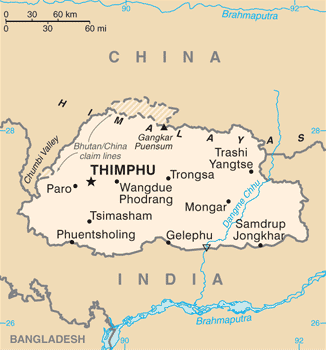
Bhutan_CIA_WFB_2010_map.png (326 × 350 pixel, meud an fhaidhle: 16 KB, seòrsa MIME: image/png)

|
This map image could be re-created using vector graphics as an SVG file. This has several advantages; see Commons:Media for cleanup for more information. If an SVG form of this image is available, please upload it and afterwards replace this template with
{{vector version available|new image name}}.
It is recommended to name the SVG file “Bhutan CIA WFB 2010 map.svg”—then the template Vector version available (or Vva) does not need the new image name parameter. |
Gearr-chunntas
| Tuairisgeul | Bhutan map from CIA World Factbook (since June 24, 2010) |
| Ceann-là | |
| Tùs |
CIA World Factbook, converted from original GIF format |
| Ùghdar | United States Central Intelligence Agency |
| Other versions |
|
Ceadachadh
This image is in the public domain because it contains materials that originally came from the United States Central Intelligence Agency's World Factbook.
|
 |
Eachdraidh an fhaidhle
Briog air ceann-là/àm gus am faidhle a shealltainn mar a nochd e aig an àm sin.
| Ceann-là/Àm | Dealbhag | Meud | Cleachdaiche | Beachd | |
|---|---|---|---|---|---|
| làithreach | 19:40, 6 dhen Iuchar 2017 | | 326 × 350 (16 KB) | Ras67 | cropped, opt. |
| 11:56, 12 dhen Chèitean 2015 |  | 330 × 354 (52 KB) | Evolt | Updated to version as of April 24, 2015 | |
| 12:17, 22 dhen Lùnastal 2011 |  | 330 × 354 (18 KB) | Zyxw | =={{int:filedesc}}== {{Information | Description = Bhutan map from CIA World Factbook ([http://web.archive.org/web/20100704230847/https://www.cia.gov/library/publications/the-world-factbook/geos/bt.html since June 24, 2010]) | Source = CIA World Factbook, |
Cleachdadh an fhaidhle
Tha ceangal ris an fhaidhle seo san duilleag a leanas:
Cleachdadh fhaidhlichean uile-choitcheann
Tha na uicidhean eile a leanas a’ cleachdadh an fhaidhle seo
- Cleachdadh air ace.wikipedia.org
- Cleachdadh air af.wikipedia.org
- Cleachdadh air als.wikipedia.org
- Cleachdadh air ar.wikipedia.org
- Cleachdadh air as.wikipedia.org
- Cleachdadh air bcl.wikipedia.org
- Cleachdadh air bh.wikipedia.org
- Cleachdadh air bjn.wikipedia.org
- Cleachdadh air bn.wikipedia.org
- Cleachdadh air ca.wikipedia.org
- Cleachdadh air cy.wikipedia.org
- Cleachdadh air da.wikipedia.org
- Cleachdadh air de.wikipedia.org
- Cleachdadh air de.wiktionary.org
- Cleachdadh air dv.wikipedia.org
- Cleachdadh air dz.wikipedia.org
- Cleachdadh air en.wikipedia.org
- Cleachdadh air en.wiktionary.org
- Cleachdadh air eo.wikipedia.org
- Cleachdadh air es.wikipedia.org
- Cleachdadh air eu.wikipedia.org
- Cleachdadh air fa.wikipedia.org
- Cleachdadh air fi.wikipedia.org
Seall an corr dhen chleachdadh uile-choitcheann a nithear dhen fhaidhle seo.