
Faidhle:Bg-map.png
Chan eil dùmhlachd-bhreacaidh nas fhearr ri fhaighinn.
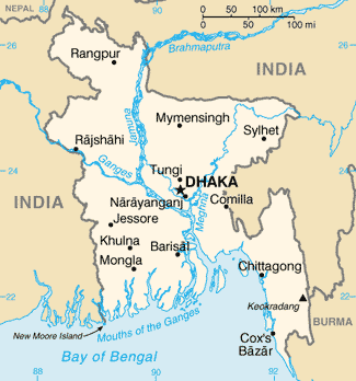
Bg-map.png (325 × 348 pixel, meud an fhaidhle: 16 KB, seòrsa MIME: image/png)
Gearr-chunntas
| Tuairisgeul |
Azərbaycanca: Bangladeşin xəritəsi
Bislama: Map blong Bangladesh
বাংলা: বাংলাদেশের মানচিত্র
Esperanto: Mapo de Bangladeŝo
Español: Mapa de Bangladesh |
| Ceann-là | |
| Tùs |
CIA World Factbook |
| Ùghdar | United States Central Intelligence Agency |
| Other versions |
|
Ceadachadh
This image is in the public domain because it contains materials that originally came from the United States Central Intelligence Agency's World Factbook.
|
 |
Derivative works


Eachdraidh an fhaidhle
Briog air ceann-là/àm gus am faidhle a shealltainn mar a nochd e aig an àm sin.
| Ceann-là/Àm | Dealbhag | Meud | Cleachdaiche | Beachd | |
|---|---|---|---|---|---|
| làithreach | 18:39, 12 dhen Mhàrt 2022 | | 325 × 348 (16 KB) | Lojwe | Cropped 2 % horizontally, 2 % vertically using CropTool with precise mode. |
| 22:38, 26 dhen Ghearran 2005 |  | 330 × 354 (16 KB) | Alfio | CIA map of Bangladesh |
Cleachdadh an fhaidhle
Tha ceangal ris an fhaidhle seo san duilleag a leanas:
Cleachdadh fhaidhlichean uile-choitcheann
Tha na uicidhean eile a leanas a’ cleachdadh an fhaidhle seo
- Cleachdadh air ar.wikipedia.org
- Cleachdadh air as.wikipedia.org
- Cleachdadh air az.wikipedia.org
- Cleachdadh air ban.wikipedia.org
- Cleachdadh air ba.wikipedia.org
- Cleachdadh air bg.wikipedia.org
- Cleachdadh air bg.wiktionary.org
- Cleachdadh air bn.wikipedia.org
- Cleachdadh air bn.wiktionary.org
- Cleachdadh air ca.wikipedia.org
- Cleachdadh air ce.wikipedia.org
- Cleachdadh air cv.wikipedia.org
- Cleachdadh air da.wikipedia.org
- Cleachdadh air de.wikipedia.org
- Cleachdadh air de.wikinews.org
- Cleachdadh air de.wiktionary.org
- Cleachdadh air dsb.wikipedia.org
- Cleachdadh air el.wikipedia.org
- Cleachdadh air en.wikipedia.org
Seall an corr dhen chleachdadh uile-choitcheann a nithear dhen fhaidhle seo.