
Faidhle:Austrian Empire (1815).svg

Size of this PNG preview of this SVG file: 450 × 456 piogsail. Dùmhlachdan-breacaidh eile: 237 × 240 piogsail | 474 × 480 piogsail | 758 × 768 piogsail | 1,011 × 1,024 piogsail | 2,021 × 2,048 piogsail.
Am faidhle tùsail (Faidhle SVG, a-rèir ainm 450 × 456 pixel, meud faidhle: 691 KB)
Gearr-chunntas


.svg)
.svg)
.svg)
.svg)
.svg)


.svg)
.svg)
.svg)


.png)
.png)


.svg)


.svg)

.svg)


.svg)
.svg)
.svg)
.svg)


.svg)
.png)


.svg)


.svg)
.svg)


.svg)


.svg)


.svg)
.svg)
.svg)
.svg)
.svg)
.svg)
.svg)
.svg)
_cropped.svg)
.svg)
.svg)
.svg)
.svg)
.svg)
.svg)
.svg)
.svg)
.svg)
.svg)
.svg)
.svg)
.svg)
.svg)
.svg)
.svg)
.svg)
.svg)
.svg)
.svg)
.svg)
.svg)
.svg)
.svg)
.svg)
.svg)
.svg)
.svg)
.svg)
.svg)
.svg)
.svg)
.svg)
.svg)
.svg)
.svg)
.svg)
.svg)
.svg)
.svg)
.svg)
.svg)
.svg)
.svg)
.svg)
Eachdraidh an fhaidhle
Briog air ceann-là/àm gus am faidhle a shealltainn mar a nochd e aig an àm sin.
| Ceann-là/Àm | Dealbhag | Meud | Cleachdaiche | Beachd | |
|---|---|---|---|---|---|
| làithreach | 09:58, 16 dhen Ghiblean 2019 | | 450 × 456 (691 KB) | TRAJAN 117 | +++ |
| 21:20, 12 dhen Lùnastal 2013 |  | 450 × 456 (654 KB) | TRAJAN 117 | Update | |
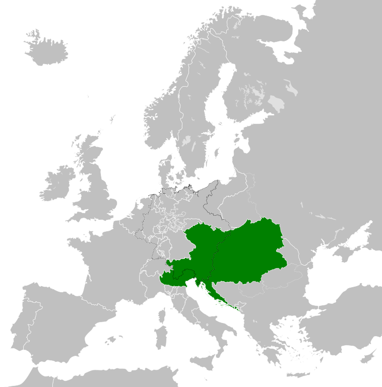
| 05:47, 12 dhen Lùnastal 2013 |  | 450 × 456 (1 MB) | TRAJAN 117 | {{Information |Description ={{en|1=The Austrian Empire in 1815.}} |Source ={{own}} {{AttribSVG|Blank map of Europe 1815.svg|Alphathon}} |Author =TRAJAN 117 {{created with Inkscape}} |Date =2013-08-12 |Pe... |
Cleachdadh an fhaidhle
Tha ceangal ris an fhaidhle seo san duilleag a leanas:
Cleachdadh fhaidhlichean uile-choitcheann
Tha na uicidhean eile a leanas a’ cleachdadh an fhaidhle seo
- Cleachdadh air af.wikipedia.org
- Cleachdadh air ast.wikipedia.org
- Cleachdadh air azb.wikipedia.org
- Cleachdadh air ba.wikipedia.org
- Cleachdadh air bg.wikipedia.org
- Cleachdadh air br.wikipedia.org
- Cleachdadh air ce.wikipedia.org
- Cleachdadh air cs.wikipedia.org
- Cleachdadh air cy.wikipedia.org
- Cleachdadh air de.wikipedia.org
- Cleachdadh air el.wikipedia.org
- Cleachdadh air en.wikipedia.org
- Cleachdadh air es.wikipedia.org
- Cleachdadh air fi.wikipedia.org
- Cleachdadh air frr.wikipedia.org
- Cleachdadh air fr.wikipedia.org
- Cleachdadh air ga.wikipedia.org
- Cleachdadh air gl.wikipedia.org
- Cleachdadh air he.wikipedia.org
- Cleachdadh air hi.wikipedia.org
- Cleachdadh air hr.wikipedia.org
- Cleachdadh air hy.wikipedia.org
- Cleachdadh air id.wikipedia.org
- Cleachdadh air id.wikibooks.org
- Cleachdadh air incubator.wikimedia.org
- Cleachdadh air is.wikipedia.org
- Cleachdadh air it.wikipedia.org
- Cleachdadh air jam.wikipedia.org
- Cleachdadh air ja.wikipedia.org
- Cleachdadh air ka.wikipedia.org
- Cleachdadh air km.wikipedia.org
- Cleachdadh air ko.wikipedia.org
- Cleachdadh air ky.wikipedia.org
- Cleachdadh air lmo.wikipedia.org
- Cleachdadh air lt.wikipedia.org
- Cleachdadh air lv.wikipedia.org
- Cleachdadh air mk.wikipedia.org
- Cleachdadh air mn.wikipedia.org
- Cleachdadh air nap.wikipedia.org
- Cleachdadh air nl.wikipedia.org
- Cleachdadh air pa.wikipedia.org
Seall an corr dhen chleachdadh uile-choitcheann a nithear dhen fhaidhle seo.
.svg)
.svg)