
Faidhle:Ac.prussiamap3.png
Chan eil dùmhlachd-bhreacaidh nas fhearr ri fhaighinn.
Ac.prussiamap3.png (716 × 425 pixel, meud an fhaidhle: 49 KB, seòrsa MIME: image/png)
Gearr-chunntas
| Tuairisgeul |
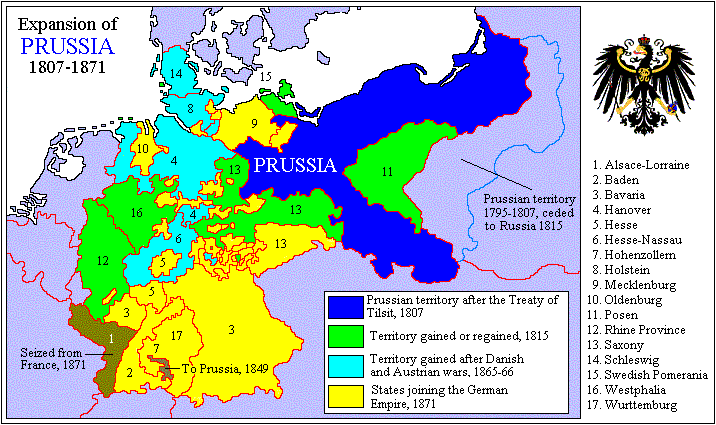
English: Expansion of Prussia. |
| Tùs | M’ obair fhèin |
| Ùghdar | Adam Carr at Beurla Uicipeid |

|
This map has been uploaded by Electionworld from en.wikipedia.org to enable the |
Ceadachadh

|
Permission is granted to copy, distribute and/or modify this document under the terms of the GNU Free Documentation License, Version 1.2 or any later version published by the Free Software Foundation; with no Invariant Sections, no Front-Cover Texts, and no Back-Cover Texts. A copy of the license is included in the section entitled GNU Free Documentation License. |
| Tha am faidhle seo fo cheadachas Creative Commons Attribution-Share Alike 3.0 Unported. | ||
| ||
| This licensing tag was added to this file as part of the GFDL licensing update. |
Original upload log
| Ceann-là/Àm | Meud | Cleachdaiche | Beachd |
|---|---|---|---|
| 22 dhen Dùbhlachd 2006, 23:32:18 | 716 × 425 (45112 bytes) | Electionworld (deasbaireachd · mùthaidhean) | {{ew|en|Adam Carr}} Expansion of Prussia {{GFDL}} [[Category:Maps of the history of Germany]] |
Eachdraidh an fhaidhle
Briog air ceann-là/àm gus am faidhle a shealltainn mar a nochd e aig an àm sin.
| Ceann-là/Àm | Dealbhag | Meud | Cleachdaiche | Beachd | |
|---|---|---|---|---|---|
| làithreach | 20:52, 5 dhen Lùnastal 2014 | | 716 × 425 (49 KB) | GifTagger | Bot: Converting file to superior PNG file. (Source: Ac.prussiamap3.gif). This GIF was problematic due to non-greyscale color table. |
Cleachdadh an fhaidhle
Tha ceangal ris an fhaidhle seo san duilleag a leanas:
Cleachdadh fhaidhlichean uile-choitcheann
Tha na uicidhean eile a leanas a’ cleachdadh an fhaidhle seo
- Cleachdadh air ar.wikipedia.org
- Cleachdadh air be.wikipedia.org
- Cleachdadh air bg.wikipedia.org
- Cleachdadh air ca.wikipedia.org
- Cleachdadh air de.wikipedia.org
- Cleachdadh air en.wikipedia.org
- House of Hohenzollern
- Kingdom of Prussia
- Prussia
- User:Adam Carr/My archive of original cartographic contributions
- Prussian Army
- Wikipedia:Graphics Lab/Image workshop/Archive/Jun 2009
- German question
- User:Basler04/GQ
- User:Tisquesusa/sandbox9
- User:Falcaorib
- Wikipedia:Graphics Lab/Illustration workshop/Archive/Aug 2022
- User:JMvanDijk/Sandbox 9/Box 15/Box 3
- Cleachdadh air es.wikipedia.org
- Cleachdadh air et.wikipedia.org
- Cleachdadh air fa.wikipedia.org
- Cleachdadh air hr.wikipedia.org
- Cleachdadh air id.wikipedia.org
- Cleachdadh air it.wikipedia.org
- Cleachdadh air ja.wikipedia.org
- Cleachdadh air km.wikipedia.org
- Cleachdadh air lt.wikipedia.org
- Cleachdadh air mk.wikipedia.org
- Cleachdadh air nn.wikipedia.org
- Cleachdadh air no.wikipedia.org
- Cleachdadh air pl.wikipedia.org
- Cleachdadh air pt.wikipedia.org
- Cleachdadh air ro.wikipedia.org
- Cleachdadh air ru.wikipedia.org
- Cleachdadh air sh.wikipedia.org
- Cleachdadh air sl.wikipedia.org
- Cleachdadh air sq.wikipedia.org
- Cleachdadh air ta.wikipedia.org
- Cleachdadh air th.wikipedia.org
- Cleachdadh air tr.wikipedia.org
- Cleachdadh air uk.wikipedia.org
Seall an corr dhen chleachdadh uile-choitcheann a nithear dhen fhaidhle seo.