
Faidhle:New guinea named.PNG

Meud an ro-sheallaidh seo: 800 × 417 piogsail. Dùmhlachdan-breacaidh eile: 320 × 167 piogsail | 640 × 333 piogsail | 1,024 × 534 piogsail | 1,280 × 667 piogsail | 2,205 × 1,149 piogsail.
Am faidhle tùsail (2,205 × 1,149 pixel, meud an fhaidhle: 86 KB, seòrsa MIME: image/png)

|
This locator map image could be re-created using vector graphics as an SVG file. This has several advantages; see Commons:Media for cleanup for more information. If an SVG form of this image is available, please upload it and afterwards replace this template with
{{vector version available|new image name}}.
It is recommended to name the SVG file “New guinea named.svg”—then the template Vector version available (or Vva) does not need the new image name parameter. |
Gearr-chunntas
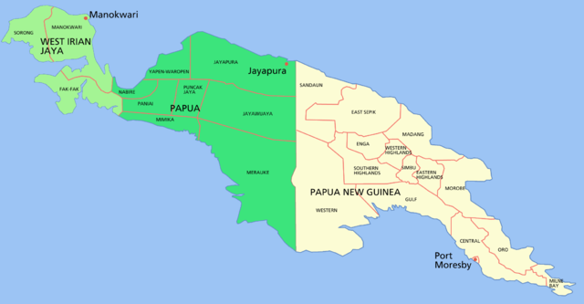
Map of the island of w:New Guinea
- Green = western New Guinea, (Indonesia) divided into the two provinces of West Irian Jaya (light green) and Papua (dark green).
- Beige = eastern New Guinea, the 'mainland' portion of the nation of Papua New Guinea
Shows capital cities and provinces
For a blank map see Image:New guinea blank.PNG
Ceadachadh

|
Permission is granted to copy, distribute and/or modify this document under the terms of the GNU Free Documentation License, Version 1.2 or any later version published by the Free Software Foundation; with no Invariant Sections, no Front-Cover Texts, and no Back-Cover Texts. A copy of the license is included in the section entitled GNU Free Documentation License. |
| Tha am faidhle seo fo cheadachas Creative Commons Attribution-Share Alike 3.0 Unported. | ||
| ||
| This licensing tag was added to this file as part of the GFDL licensing update. |
Eachdraidh an fhaidhle
Briog air ceann-là/àm gus am faidhle a shealltainn mar a nochd e aig an àm sin.
| Ceann-là/Àm | Dealbhag | Meud | Cleachdaiche | Beachd | |
|---|---|---|---|---|---|
| làithreach | 04:29, 24 dhen Ghearran 2006 | | 2,205 × 1,149 (86 KB) | Roke~commonswiki | Map of the island of New Guinea Category: New Guinea |
Cleachdadh an fhaidhle
Tha ceangal ris an fhaidhle seo san duilleag a leanas:
Cleachdadh fhaidhlichean uile-choitcheann
Tha na uicidhean eile a leanas a’ cleachdadh an fhaidhle seo
- Cleachdadh air af.wikipedia.org
- Cleachdadh air als.wikipedia.org
- Cleachdadh air ar.wikipedia.org
- Cleachdadh air ban.wikipedia.org
- Cleachdadh air bat-smg.wikipedia.org
- Cleachdadh air ca.wikipedia.org
- Cleachdadh air cs.wikipedia.org
- Cleachdadh air de.wikipedia.org
- Cleachdadh air de.wikinews.org
- Cleachdadh air el.wikipedia.org
- Cleachdadh air en.wikipedia.org
- Cleachdadh air en.wiktionary.org
- Cleachdadh air es.wikipedia.org
- Cleachdadh air fa.wikipedia.org
- Cleachdadh air fi.wikipedia.org
- Cleachdadh air fr.wikipedia.org
- Cleachdadh air gl.wikipedia.org
- Cleachdadh air gn.wikipedia.org
- Cleachdadh air hak.wikipedia.org
- Cleachdadh air he.wikipedia.org
- Cleachdadh air hu.wikipedia.org
- Cleachdadh air id.wikipedia.org
- Cleachdadh air id.wiktionary.org
- Cleachdadh air ja.wikipedia.org
- Cleachdadh air ka.wikipedia.org
- Cleachdadh air ko.wikipedia.org
Seall an corr dhen chleachdadh uile-choitcheann a nithear dhen fhaidhle seo.