
Faidhle:Karte Deutschland.png
Chan eil dùmhlachd-bhreacaidh nas fhearr ri fhaighinn.
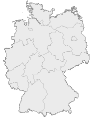
Karte_Deutschland.png (188 × 235 pixel, meud an fhaidhle: 2 KB, seòrsa MIME: image/png)
| Tuairisgeul |
English: Map of Germany with the borders of the 16 federal states.
Deutsch: Karte von Deutschland mit den Grenzen der 16 Bundesländer. |
| Ceann-là | Gun fhios air a' cheann-là |
| Tùs | OpenGeoDB |
| Ùghdar | NN/OpenGeoDB |
| Cead (Ag ath-chleachdadh an fhaidhle seo) |
GFDL |
This image was generated with OpenGeoDB. The information there is placed in the public domain, images generated from OpenGeoDB are derivative works without passing the threshold of creativity, they are therefore also public domain.
| This work is ineligible for copyright and therefore in the public domain because it consists entirely of information that is common property and contains no original authorship. |

|
File:Germany location map.svg is a vector version of this file. It should be used in place of this PNG file when not inferior.
File:Karte Deutschland.png → File:Germany location map.svg
For more information, see Help:SVG. |
 |
Eachdraidh an fhaidhle
Briog air ceann-là/àm gus am faidhle a shealltainn mar a nochd e aig an àm sin.
| Ceann-là/Àm | Dealbhag | Meud | Cleachdaiche | Beachd | |
|---|---|---|---|---|---|
| làithreach | 18:46, 8 dhen Fhaoilleach 2008 | | 188 × 235 (2 KB) | Evilboy | Reverted to version as of 20:35, 14 March 2007 |
| 20:35, 14 dhen Mhàrt 2007 |  | 188 × 235 (2 KB) | Tene~commonswiki | Optimised (0) | |
| 11:28, 9 dhen Ghearran 2007 |  | 188 × 235 (2 KB) | TMg | Contrast slightly improved without loosing precision | |
| 19:04, 31 dhen Fhaoilleach 2007 |  | 188 × 235 (2 KB) | Leit | Auf eine alte Version zurückgesetzt | |
| 18:17, 31 dhen Fhaoilleach 2007 |  | 188 × 235 (8 KB) | Der Eberswalder | ||
| 12:29, 31 dhen Fhaoilleach 2007 |  | 188 × 235 (2 KB) | Rauenstein | Auf eine alte Version zurückgesetzt | |
| 11:04, 31 dhen Fhaoilleach 2007 |  | 188 × 235 (8 KB) | Der Eberswalder | now white color outside the borders | |
| 10:31, 31 dhen Fhaoilleach 2007 |  | 188 × 235 (2 KB) | Siebrand | Eerdere versie hersteld | |
| 06:31, 31 dhen Fhaoilleach 2007 |  | 188 × 235 (9 KB) | Der Eberswalder | better viewable | |
| 15:48, 27 dhen Lùnastal 2006 |  | 188 × 235 (2 KB) | TMg | Slightly error corrected version, based on Image:Karte stralsund in deutschland-test.png by de:Benutzer:Rauenstein |
Cleachdadh an fhaidhle
Chan eil duilleag sam bith a' ceangal an-seo.
Cleachdadh fhaidhlichean uile-choitcheann
Tha na uicidhean eile a leanas a’ cleachdadh an fhaidhle seo
- Cleachdadh air ceb.wikipedia.org
- Cleachdadh air da.wikipedia.org
- Cleachdadh air de.wikipedia.org
- Cleachdadh air nds.wikipedia.org
- Landkreis Emsland
- Landkreis Rodenborg (Wümm)
- Landkreis Stood
- Landkreis Heidkreis
- Landkreis Vechte
- Landkreis Veern
- Kreis Noordfreesland
- Landkreis Cuxhoben
- Landkreis Oosterholt
- Landkreis Horborg
- Landkreis Lümborg
- Kreis Pinnbarg
- Landkreis Ollnborg
- Kreis Steenborg
- Landkreis Weißenburg-Gunzenhausen
- Landkreis Würzburg
- Landkreis Wunsiedel im Fichtelgebirge
- Landkreis Weilheim-Schongau
- Landkreis Unterallgäu
- Landkreis Traunstein
- Landkreis Tirschenreuth
- Landkreis Straubing-Bogen
- Landkreis Starnberg
- Landkreis Schweinfurt
- Landkreis Schwandorf
- Landkreis Rottal-Inn
- Landkreis Roth
- Landkreis Rosenheim
- Landkreis Rhön-Grabfeld
- Landkreis Paane
- Landkreis Wulfenbüttel
- Landkreis Groafschup Bentem
- Landkreis Hameln-Purmunt
- Landkreis Aichach-Friedberg
- Landkreis Altötting
- Landkreis Amberg-Sulzbach
- Landkreis Schaumborg
- Landkreis Ülzen
- Landraodsamt Stemmert
- Cleachdadh air pms.wikipedia.org
Seall an corr dhen chleachdadh uile-choitcheann a nithear dhen fhaidhle seo.