
Faidhle:Isle of Jersey (ASTER).jpg

Meud an ro-sheallaidh seo: 763 × 600 piogsail. Dùmhlachdan-breacaidh eile: 306 × 240 piogsail | 611 × 480 piogsail | 978 × 768 piogsail | 1,280 × 1,006 piogsail | 1,400 × 1,100 piogsail.
Am faidhle tùsail (1,400 × 1,100 pixel, meud an fhaidhle: 231 KB, seòrsa MIME: image/jpeg)
.jpg)
Gearr-chunntas
| Tuairisgeul |
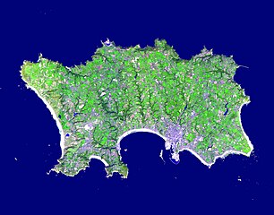
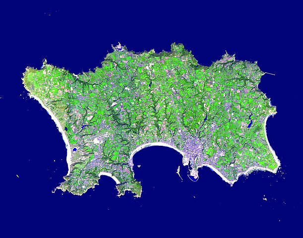
English: The Isle of Jersey (officially called the Bailiwick of Jersey) is the largest Channel Island, positioned in the Bay of Mont St Michel off the north-west coast of France. The island has a population of about 90,000, and covers about 90 square kilometers. The economy is based largely on international financial services, agriculture, and tourism. Called Caesaria in Roman times, Jersey became part of the Duchy of Normandy in 912. When William the Conqueror invaded and took the throne of England in 1066, the fortunes of Jersey then became linked to those in England, although the island manages its internal affairs through its own parliament, the States of Jersey. This image was acquired September 23, 2000, covers an area of 16.5 x 21 km, and is located at 49.2 degrees north latitude and 2.1 degrees west longitude |
||
| Ceann-là | Taken on 23 dhen t-Sultain 2000 | ||
| Tùs |
|
||
| Ùghdar | NASA/METI/AIST/Japan Space Systems, and U.S./Japan ASTER Science Team |
| Camera location | | View this and other nearby images on: OpenStreetMap |
|---|
.jpg¶ms=049.200000_N_-002.100000_E_globe:Earth_type:camera__&language=gd)
Ceadachadh
| This file is in the public domain in the United States because it was solely created by NASA. NASA copyright policy states that "NASA material is not protected by copyright unless noted". (See Template:PD-USGov, NASA copyright policy page or JPL Image Use Policy.) | ||
 |
Warnings:
|
Eachdraidh an fhaidhle
Briog air ceann-là/àm gus am faidhle a shealltainn mar a nochd e aig an àm sin.
| Ceann-là/Àm | Dealbhag | Meud | Cleachdaiche | Beachd | |
|---|---|---|---|---|---|
| làithreach | 15:48, 30 dhen Ghiblean 2023 | | 1,400 × 1,100 (231 KB) | OptimusPrimeBot | #Spacemedia - Upload of https://asterweb.jpl.nasa.gov/gallery/images/jersey.jpg via Commons:Spacemedia |
Cleachdadh an fhaidhle
Tha ceangal ris an fhaidhle seo san duilleag a leanas:
Cleachdadh fhaidhlichean uile-choitcheann
Tha na uicidhean eile a leanas a’ cleachdadh an fhaidhle seo
- Cleachdadh air br.wikipedia.org
- Cleachdadh air en.wikipedia.org
- Minquiers and Ecréhous
- Saint Aubin, Jersey
- Les Dirouilles
- Vingtaine de Noirmont
- Vingtaine du Coin
- Vingtaine des Quennevais
- Vingtaine de la Moye
- Vingtaine de Samarès
- Grande Vingtaine (St Clement)
- Vingtaine du Rocquier
- Vingtaine de la Rocque
- Vingtaine des Marais
- Vingtaine de la Rue
- Vingtaine de Longueville
- Vingtaine du Rouge Bouillon
- Vingtaine de Bas du Mont au Prêtre
- Vingtaine du Mont à l'Abbé
- Vingtaine de Haut du Mont au Prêtre
- Vingtaine du Mont Cochon
- St Michael's Preparatory School
- Grouville Church
- St Peter la Rocque
- Vingtaine du Nord (St John)
- Vingtaine de Hérupe
- Vingtaine du Douet (St John)
- Template:Jersey-geo-stub
- Outline of Jersey
- Nicolle Tower
- Vingtaine de la Vallée
- Vingtaine du Coin Hâtain
- Vingtaine du Coin Motier
- Vingtaine du Coin Tourgis Sud
- Les Platons
- HM Prison La Moye
- Vingtaine du Nord (St Mary)
- Grainville School
- St Matthew's Church, Jersey
- Gulf of Saint-Malo
- Samarès Manor
- Saint Ouen's Manor
- FB Playing Fields
- Saint Helier Marina
- Vingtaine du Sud
- Vingtaine de Rozel
- Vingtaine de Faldouet
- Vingtaine de la Quéruée
- Vingtaine des Augrès
- Le Pinacle
- Beaulieu Convent School
Seall an corr dhen chleachdadh uile-choitcheann a nithear dhen fhaidhle seo.
.jpg)
.jpg)