
Faidhle:Indonesia provinces english.png

Meud an ro-sheallaidh seo: 800 × 365 piogsail. Dùmhlachdan-breacaidh eile: 320 × 146 piogsail | 640 × 292 piogsail | 1,628 × 742 piogsail.
Am faidhle tùsail (1,628 × 742 pixel, meud an fhaidhle: 92 KB, seòrsa MIME: image/png)

|
File:Indonesia, administrative divisions - en - monochrome.svg is a vector version of this file. It should be used in place of this PNG file when not inferior.
File:Indonesia provinces english.png → File:Indonesia, administrative divisions - en - monochrome.svg
For more information, see Help:SVG. |
 |

|
This file requires updating because: In 2022, the Papua provinces changed from 2 provinces to 6 provinces. In doing so, you could add a timestamp to the file.
|
Gearr-chunntas
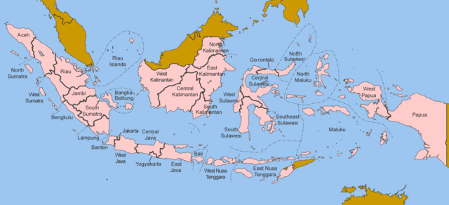
Map of the provinces of Indonesia in English.
Made by User:Golbez based on a PD CIA map, using other sources to guesstimate the extent of West Irian Jaya and West Sulawesi.
derivative works
Derivative works of this file: Indonesia, administrative divisions - en - monochrome.svg
Ceadachadh
I, the copyright holder of this work, hereby publish it under the following licenses:

|
Permission is granted to copy, distribute and/or modify this document under the terms of the GNU Free Documentation License, Version 1.2 or any later version published by the Free Software Foundation; with no Invariant Sections, no Front-Cover Texts, and no Back-Cover Texts. A copy of the license is included in the section entitled GNU Free Documentation License. |
| Tha am faidhle seo fo cheadachas Creative Commons Attribution-Share Alike 3.0 Unported. | ||
| ||
| This licensing tag was added to this file as part of the GFDL licensing update. |
This file is licensed under the Creative Commons Attribution 2.5 Generic license.
- Faodaidh tu:
- a cho-roinneadh – lethbhreac a dhèanamh dhen obair, a sgaoileadh is a tar-chur
- ath-mheasgachadh – an obair atharrachadh
- Fo bhuaidh nan cumhaichean a leanas:
- urram – Feumaidh tu iomradh a thoirt air an ùghdar no an neach aig a bheil cead air, dìreach mar a thoill iad (ach chan ann air dòigh a chuireas an sùilean dhaoine gu bheil iad ag aontachadh riut no ri d’ obair).
’S urrainn dhut an ceadachas as fhearr leat a thaghadh.
Eachdraidh an fhaidhle
Briog air ceann-là/àm gus am faidhle a shealltainn mar a nochd e aig an àm sin.
| Ceann-là/Àm | Dealbhag | Meud | Cleachdaiche | Beachd | |
|---|---|---|---|---|---|
| làithreach | 12:40, 25 dhen Dàmhair 2020 | | 1,628 × 742 (92 KB) | Afrogindahood | Addition of North Kalimantan province |
| 07:54, 8 dhen Fhaoilleach 2006 | 1,500 × 590 (77 KB) | Golbez | Map of the provinces of Indonesian in English. Made by User:Golbez based on a PD CIA map, using other sources to guesstimate the extent of West Irian Jaya and West Sulawesi. Category:Maps of Indonesia |
Cleachdadh an fhaidhle
Tha ceangal ris an fhaidhle seo san duilleag a leanas:
Cleachdadh fhaidhlichean uile-choitcheann
Tha na uicidhean eile a leanas a’ cleachdadh an fhaidhle seo
- Cleachdadh air arz.wikipedia.org
- Cleachdadh air ba.wikipedia.org
- Cleachdadh air be-tarask.wikipedia.org
- Cleachdadh air blk.wikipedia.org
- Cleachdadh air bxr.wikipedia.org
- Cleachdadh air ca.wikipedia.org
- Cleachdadh air ceb.wikipedia.org
- Cleachdadh air crh.wikipedia.org
- Cleachdadh air csb.wikipedia.org
- Cleachdadh air cs.wikipedia.org
- Cleachdadh air cy.wikipedia.org
- Cleachdadh air da.wikipedia.org
- Cleachdadh air diq.wikipedia.org
- Cleachdadh air dv.wikipedia.org
- Cleachdadh air en.wikipedia.org
- Cleachdadh air es.wikipedia.org
- Cleachdadh air fr.wikipedia.org
- Cleachdadh air gl.wikipedia.org
- Cleachdadh air ht.wikipedia.org
- Cleachdadh air hu.wikipedia.org
- Cleachdadh air incubator.wikimedia.org
- Cleachdadh air it.wikipedia.org
- Cleachdadh air ja.wikipedia.org
- Cleachdadh air kaa.wikipedia.org
- Cleachdadh air kk.wikipedia.org
- Cleachdadh air km.wikipedia.org
- Cleachdadh air kn.wikipedia.org
- Cleachdadh air kv.wikipedia.org
- Cleachdadh air kw.wikipedia.org
- Cleachdadh air lij.wikipedia.org
- Cleachdadh air lmo.wikipedia.org
- Cleachdadh air ln.wikipedia.org
- Cleachdadh air lv.wikipedia.org
- Cleachdadh air mg.wikipedia.org
- Cleachdadh air mhr.wikipedia.org
- Cleachdadh air ml.wikipedia.org
- Cleachdadh air mn.wikipedia.org
- Cleachdadh air my.wikipedia.org
- Cleachdadh air mzn.wikipedia.org
- Cleachdadh air new.wikipedia.org
- Cleachdadh air nl.wikipedia.org
- Cleachdadh air nn.wikipedia.org
- Cleachdadh air pag.wikipedia.org
- Cleachdadh air pam.wikipedia.org
- Cleachdadh air pap.wikipedia.org
- Cleachdadh air pms.wikipedia.org
- Cleachdadh air pnb.wikipedia.org
- Cleachdadh air qu.wikipedia.org
Seall an corr dhen chleachdadh uile-choitcheann a nithear dhen fhaidhle seo.