
Faidhle:Gran Colombia map.jpg

Meud an ro-sheallaidh seo: 800 × 580 piogsail. Dùmhlachdan-breacaidh eile: 320 × 232 piogsail | 640 × 464 piogsail | 1,024 × 742 piogsail | 1,280 × 928 piogsail | 2,407 × 1,745 piogsail.
Am faidhle tùsail (2,407 × 1,745 pixel, meud an fhaidhle: 1.35 MB, seòrsa MIME: image/jpeg)
Gearr-chunntas
| Tuairisgeul |
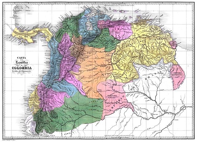
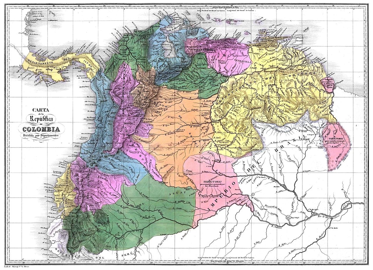
Español: Carta de la República de Colombia dividida en 12 departamentos en 1824. Tomado del Atlas físico y político de la República de Venezuela, 1840.
English: Map of the Greater Colombia
Français : Carte de la Grande Colombie
Deutsch: Diagramm des Großkolumbien |
||||||||||||||||||||
| Ceann-là | |||||||||||||||||||||
| Tùs | Historical Maps by Agustín Codazzi, from David Rumsey Website | ||||||||||||||||||||
| Ùghdar |
|
||||||||||||||||||||
| Cead (Ag ath-chleachdadh an fhaidhle seo) |
|
||||||||||||||||||||
| Other versions | العربيَّة | ||||||||||||||||||||

Eachdraidh an fhaidhle
Briog air ceann-là/àm gus am faidhle a shealltainn mar a nochd e aig an àm sin.
| Ceann-là/Àm | Dealbhag | Meud | Cleachdaiche | Beachd | |
|---|---|---|---|---|---|
| làithreach | 22:15, 27 dhen Ghearran 2012 | | 2,407 × 1,745 (1.35 MB) | Josher8a | ajuste de perspectiva, eliminación de interferencias , mejoramiento de color y borrado de marcas de los dobleces y eliminación de los mismos |
| 05:37, 6 dhen Ògmhios 2008 |  | 2,407 × 1,745 (1.43 MB) | Milenioscuro | {{Information |Description= |Source= |Date= |Author= |Permission= |other_versions= }} | |
| 18:13, 7 dhen Dùbhlachd 2007 |  | 1,235 × 893 (216 KB) | Milenioscuro | {{Information |Description=Gran Colombia 1824 |Source=David Rumsey Historic Maps website |Date= |Author=User:Shadowxfox |Permission= |other_versions= }} | |
| 17:56, 29 dhen Dàmhair 2006 |  | 778 × 610 (107 KB) | Fausthe | It is a historical map for the Gran Colombia www.simon-bolivar.org |
Cleachdadh an fhaidhle
Tha ceangal ris an fhaidhle seo san duilleag a leanas:
Cleachdadh fhaidhlichean uile-choitcheann
Tha na uicidhean eile a leanas a’ cleachdadh an fhaidhle seo
- Cleachdadh air ast.wikipedia.org
- Cleachdadh air bn.wikipedia.org
- Cleachdadh air ca.wikipedia.org
- Cleachdadh air cs.wikipedia.org
- Cleachdadh air en.wikipedia.org
- Cleachdadh air eo.wikipedia.org
- Cleachdadh air es.wikipedia.org
- Simón Bolívar
- Historia de Venezuela
- Guyana
- Valencia (Venezuela)
- Antonio José de Sucre
- Independencia de Venezuela
- Historia de Guyana
- Historia del Ecuador
- Batalla de Pichincha
- Usuario:Felipnator
- Discusión:Historia territorial de Colombia/Archivo1
- Usuario:Vilavikensis
- Tratado de Guayaquil
- Política exterior de Venezuela
- Expulsión de los españoles de América
- Frontera entre Colombia y Ecuador
- Conservadurismo en Venezuela
- Cleachdadh air fr.wikipedia.org
- Cleachdadh air gl.wikipedia.org
- Cleachdadh air he.wikipedia.org
- Cleachdadh air hr.wikipedia.org
Seall an corr dhen chleachdadh uile-choitcheann a nithear dhen fhaidhle seo.