
Faidhle:Falkland Islands map.svg

Size of this PNG preview of this SVG file: 769 × 600 piogsail. Dùmhlachdan-breacaidh eile: 308 × 240 piogsail | 616 × 480 piogsail | 985 × 768 piogsail | 1,280 × 998 piogsail | 2,560 × 1,996 piogsail | 1,090 × 850 piogsail.
Am faidhle tùsail (Faidhle SVG, a-rèir ainm 1,090 × 850 pixel, meud faidhle: 583 KB)

|
This file has been superseded by Falkland Islands topographic map-en.svg. It is recommended to use the other file. Please note that deleting superseded images requires consent. Reason to use the other file: "More precise map; created from NASA's digital elevation model"
|

|
Gearr-chunntas
| Tuairisgeul |
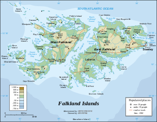
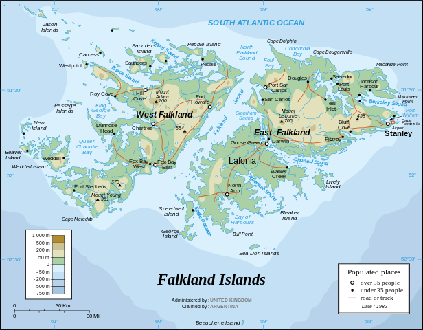
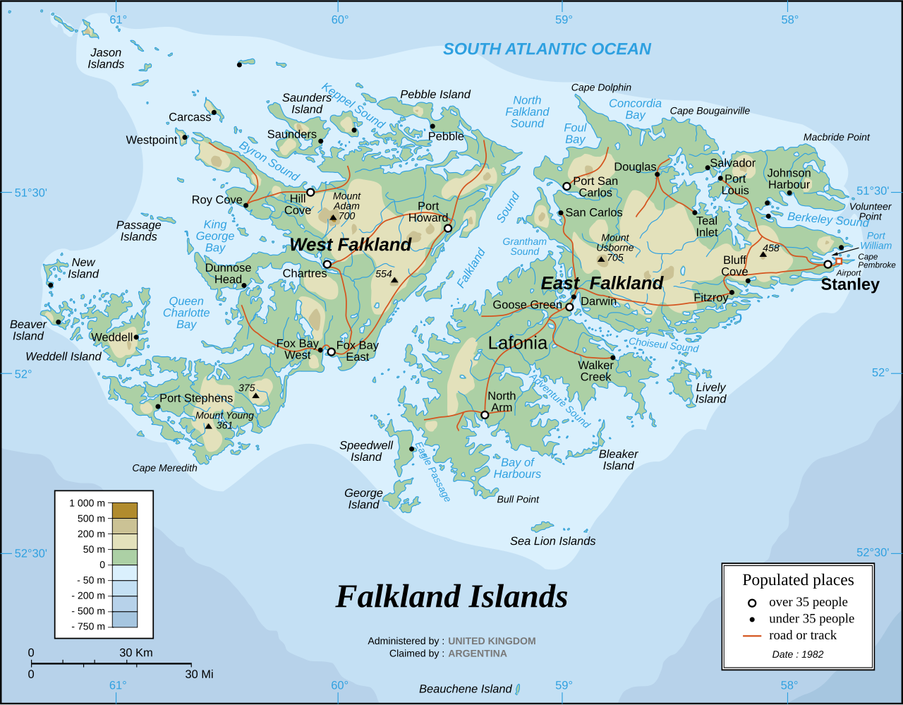
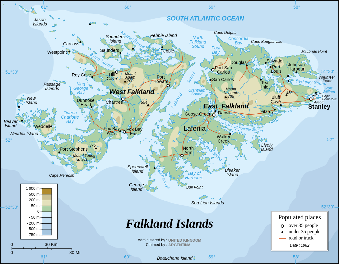
English: The Falkland Islands are an archipelago in the South Atlantic Ocean, located 300 miles off the coast of Argentina. They consist of two main islands, East Falkland and West Falkland, together with about 700 smaller islands. Stanley, on East Falkland, is the capital and largest city. The islands are a self-governing Overseas Territory of the United Kingdom, but have been the subject of a claim to sovereignty by Argentina since the British invasion of 1833.
Français : Carte en anglais des îles Malouines |
| Ceann-là | |
| Tùs |
Own work Background and elevation reference maps : Microsoft Encarta atlas (1999 edition) and UK government map 1982 demographic data : CIA map available on the site of the University of Texas at Austin |
| Ùghdar | Eric Gaba (Sting) |
| Other versions | in French: Iles Malouines carte.svg |
| SVG genesis |
Français :
- Sujet : Carte en anglais des îles Malouines ;
- Sources : Création personnelle
- Fond de carte et relief basés sur : atlas Encarta de Microsoft (édition 1999) et carte du gouvernement britannique ;
- Données démographiques de 1982 : carte de la CIA disponible sur la site de l'Université du Texas à Austin ;
- Auteur : Eric Gaba (fr:Sting) ;
- Date : Septembre 2006.
- Autre version : francophone : Image:Iles_Malouines_carte.svg
Ceadachadh
I, the copyright holder of this work, hereby publish it under the following license:
This file is licensed under the Creative Commons Attribution-Share Alike 2.5 Generic license.
- Faodaidh tu:
- a cho-roinneadh – lethbhreac a dhèanamh dhen obair, a sgaoileadh is a tar-chur
- ath-mheasgachadh – an obair atharrachadh
- Fo bhuaidh nan cumhaichean a leanas:
- urram – Feumaidh tu iomradh a thoirt air an ùghdar no an neach aig a bheil cead air, dìreach mar a thoill iad (ach chan ann air dòigh a chuireas an sùilean dhaoine gu bheil iad ag aontachadh riut no ri d’ obair).
- co-roinneadh co-ionnann – Ma dh’atharraicheas tu no ma leasaicheas tu an obair seo, ’s urrainn an tionndadh ùr fon cheadachas seo no fo cheadachas coltach ris.
Eachdraidh an fhaidhle
Briog air ceann-là/àm gus am faidhle a shealltainn mar a nochd e aig an àm sin.
| Ceann-là/Àm | Dealbhag | Meud | Cleachdaiche | Beachd | |
|---|---|---|---|---|---|
| làithreach | 20:06, 31 dhen Mhàrt 2007 | | 1,090 × 850 (583 KB) | Sting | Some text corrections |
| 02:58, 28 dhen t-Sultain 2006 |  | 1,090 × 850 (586 KB) | Sting | Cosmetic correction | |
| 02:48, 28 dhen t-Sultain 2006 |  | 1,090 × 850 (586 KB) | Sting | {{Information |Description=Map of the Falkland Islands |Source=1982 demographic data : [http://www.lib.utexas.edu/maps/americas/falkland_islands.gif CIA map] available on the site of the [http://www.lib.utexas.edu/maps/americas.html#F University of Texas |
Cleachdadh an fhaidhle
Tha ceangal ris an fhaidhle seo san duilleag a leanas:
Cleachdadh fhaidhlichean uile-choitcheann
Tha na uicidhean eile a leanas a’ cleachdadh an fhaidhle seo
- Cleachdadh air azb.wikipedia.org
- Cleachdadh air de.wikipedia.org
- Cleachdadh air en.wikipedia.org
- Cleachdadh air es.wikinews.org
- Cleachdadh air he.wikipedia.org
- Cleachdadh air it.wikipedia.org
- Cleachdadh air ja.wikipedia.org
- Cleachdadh air lt.wikipedia.org
- Cleachdadh air no.wikipedia.org
- Cleachdadh air ro.wikipedia.org
- Cleachdadh air sr.wikipedia.org
- Cleachdadh air wuu.wikipedia.org