
Faidhle:EasternRomanEmpire.png
Chan eil dùmhlachd-bhreacaidh nas fhearr ri fhaighinn.
EasternRomanEmpire.png (250 × 175 pixel, meud an fhaidhle: 7 KB, seòrsa MIME: image/png)

|
This map has been uploaded by Electionworld from en.wikipedia.org to enable the |

|
The copyright holder of this work allows anyone to use it for any purpose including unrestricted redistribution, commercial use, and modification.
|
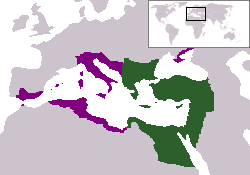
The territory in green represents the core areas held by the Eastern Roman Empire before the Muslim conquests The territory in purple represents the greatest extent of the Byzantine Empire under Emperor Justinian I
Eachdraidh an fhaidhle
Briog air ceann-là/àm gus am faidhle a shealltainn mar a nochd e aig an àm sin.
| Ceann-là/Àm | Dealbhag | Meud | Cleachdaiche | Beachd | |
|---|---|---|---|---|---|
| làithreach | 18:27, 13 dhen Dùbhlachd 2006 | | 250 × 175 (7 KB) | Electionworld | {{ew|en|24630}} {{CopyrightedFreeUse-User|24630}} The territory in green represents the core areas held by the Eastern Roman Empire before the Muslim conquests The territory in purple represents the greatest extent of the Byzantine Empire unde |
Cleachdadh an fhaidhle
Tha ceangal ris an fhaidhle seo san duilleag a leanas:
Cleachdadh fhaidhlichean uile-choitcheann
Tha na uicidhean eile a leanas a’ cleachdadh an fhaidhle seo
- Cleachdadh air da.wikipedia.org
- Cleachdadh air en.wiktionary.org
- Cleachdadh air lv.wikipedia.org
- Cleachdadh air no.wikipedia.org
- Cleachdadh air ru.wiktionary.org
- Cleachdadh air sl.wikipedia.org
- Cleachdadh air sq.wikipedia.org
- Cleachdadh air sv.wikipedia.org
- Cleachdadh air vi.wikipedia.org
- Cleachdadh air zh.wiktionary.org