
Faidhle:Cyprus topo.png
Meud an ro-sheallaidh seo: 782 × 600 piogsail. Dùmhlachdan-breacaidh eile: 313 × 240 piogsail | 626 × 480 piogsail | 1,002 × 768 piogsail | 1,280 × 981 piogsail | 1,500 × 1,150 piogsail.
Am faidhle tùsail (1,500 × 1,150 pixel, meud an fhaidhle: 1.01 MB, seòrsa MIME: image/png)
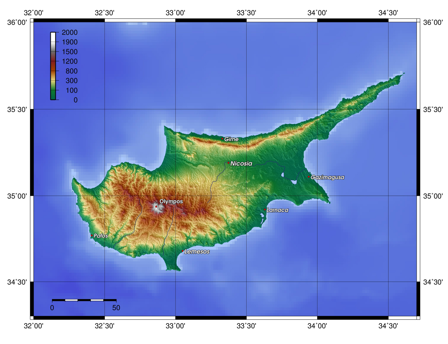
| Tuairisgeul | Description: Topography of Cyprus, created with GMT 4.1.3 | ||||||||||
| Ceann-là | |||||||||||
| Tùs |
At least one of the following Public Domain data sources |
||||||||||
| Ùghdar | Zamonin | ||||||||||
| Cead (Ag ath-chleachdadh an fhaidhle seo) |
|

Eachdraidh an fhaidhle
Briog air ceann-là/àm gus am faidhle a shealltainn mar a nochd e aig an àm sin.
| Ceann-là/Àm | Dealbhag | Meud | Cleachdaiche | Beachd | |
|---|---|---|---|---|---|
| làithreach | 13:18, 20 dhen t-Samhain 2012 | | 1,500 × 1,150 (1.01 MB) | Zamonin | new labels |
| 07:26, 8 dhen Chèitean 2009 |  | 1,500 × 1,082 (895 KB) | Zamonin | added cities used etopo1 instead of etopo2 | |
| 09:47, 7 dhen Chèitean 2009 |  | 1,500 × 1,078 (905 KB) | Zamonin | (added cities used etopo1 instead of etopo2) | |
| 13:16, 11 dhen Iuchar 2006 |  | 1,363 × 865 (886 KB) | Zamonin | Category:Maps of Cyprus == Description, Source == * Description: Topography of Cyprus, created with [http://gmt.soest.hawaii.edu/ GMT] 4.1.3 * Source: At least one of the following Public Domain data sources ** [http://http://dss.ucar.edu/datasets/d |
Cleachdadh an fhaidhle
Tha ceangal ris an fhaidhle seo san duilleag a leanas:
Cleachdadh fhaidhlichean uile-choitcheann
Tha na uicidhean eile a leanas a’ cleachdadh an fhaidhle seo
- Cleachdadh air af.wikipedia.org
- Cleachdadh air als.wikipedia.org
- Cleachdadh air ar.wikipedia.org
- Cleachdadh air bg.wikipedia.org
- Cleachdadh air bn.wikipedia.org
- Cleachdadh air cs.wikipedia.org
- Cleachdadh air de.wikibooks.org
- Cleachdadh air el.wikipedia.org
- Cleachdadh air en.wikipedia.org
- Cleachdadh air eo.wikipedia.org
- Cleachdadh air es.wikipedia.org
- Cleachdadh air fi.wikipedia.org
- Cleachdadh air fr.wikipedia.org
- Cleachdadh air he.wikipedia.org
- Cleachdadh air hr.wikipedia.org
- Cleachdadh air hu.wikipedia.org
- Cleachdadh air id.wikipedia.org
- Cleachdadh air incubator.wikimedia.org
- Cleachdadh air io.wikipedia.org
- Cleachdadh air ja.wikipedia.org
- Cleachdadh air ka.wikipedia.org
- Cleachdadh air ko.wikipedia.org
- Cleachdadh air ku.wikipedia.org
- Cleachdadh air lij.wikipedia.org
- Cleachdadh air lt.wikipedia.org
- Cleachdadh air nn.wikipedia.org
- Cleachdadh air no.wikipedia.org
- Cleachdadh air pl.wikipedia.org
- Cleachdadh air pl.wiktionary.org
- Cleachdadh air pnb.wikipedia.org
- Cleachdadh air pt.wikipedia.org
- Cleachdadh air qu.wikipedia.org
- Cleachdadh air ru.wikipedia.org
Seall an corr dhen chleachdadh uile-choitcheann a nithear dhen fhaidhle seo.