
Faidhle:Côte d'Ivoire Map.jpg
Meud an ro-sheallaidh seo: 470 × 600 piogsail. Dùmhlachdan-breacaidh eile: 188 × 240 piogsail | 376 × 480 piogsail | 602 × 768 piogsail | 1,036 × 1,322 piogsail.
Am faidhle tùsail (1,036 × 1,322 pixel, meud an fhaidhle: 440 KB, seòrsa MIME: image/jpeg)
| Tuairisgeul |
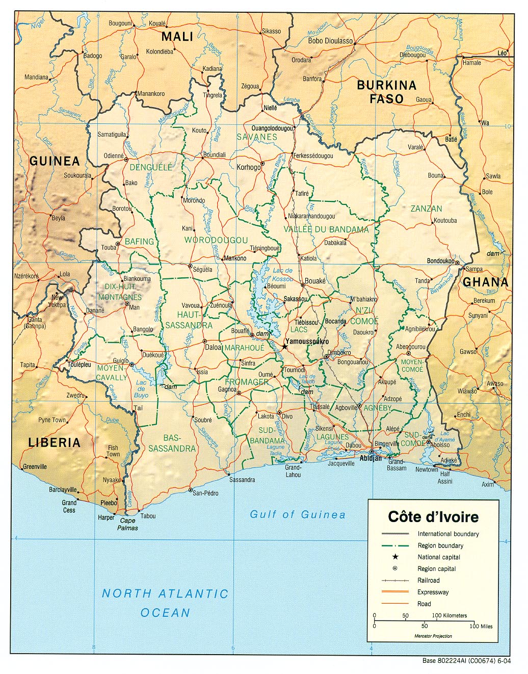
English: haded relief map of Côte d'Ivoire. |
|||
| Ceann-là | ||||
| Tùs | [1] from the Perry-Castañeda Library Map Collection. | |||
| Ùghdar | CIA | |||
| Cead (Ag ath-chleachdadh an fhaidhle seo) |
|

![[1]](http://www.lib.utexas.edu/maps/africa/cote_divoire_rel04.jpg)
Eachdraidh an fhaidhle
Briog air ceann-là/àm gus am faidhle a shealltainn mar a nochd e aig an àm sin.
| Ceann-là/Àm | Dealbhag | Meud | Cleachdaiche | Beachd | |
|---|---|---|---|---|---|
| làithreach | 11:11, 21 dhen Ghearran 2006 | | 1,036 × 1,322 (440 KB) | Lupo | Shaded relief map of Côte d'Ivoire. Source: [http://www.lib.utexas.edu/maps/africa/cote_divoire_rel04.jpg] from the [http://www.lib.utexas.edu/maps/cote_d'ivoire.html Perry-Castañeda Library Map Collection]. {{PD-USGov-CIA}} [[Category:Maps of C� |
Cleachdadh an fhaidhle
Tha ceangal ris an fhaidhle seo san duilleag a leanas:
Cleachdadh fhaidhlichean uile-choitcheann
Tha na uicidhean eile a leanas a’ cleachdadh an fhaidhle seo
- Cleachdadh air als.wikipedia.org
- Cleachdadh air ar.wikipedia.org
- Cleachdadh air az.wikipedia.org
- Cleachdadh air be.wikipedia.org
- Cleachdadh air bn.wikipedia.org
- Cleachdadh air ca.wikipedia.org
- Cleachdadh air ckb.wikipedia.org
- Cleachdadh air cv.wikipedia.org
- Cleachdadh air de.wikipedia.org
- Cleachdadh air en.wikipedia.org
- Cleachdadh air es.wikipedia.org
- Cleachdadh air fa.wikipedia.org
- Cleachdadh air fr.wikipedia.org
- Cleachdadh air fr.wikinews.org
- Cleachdadh air fy.wikipedia.org
- Cleachdadh air gl.wikipedia.org
- Cleachdadh air hi.wikipedia.org
- Cleachdadh air id.wikipedia.org
- Cleachdadh air it.wikipedia.org
- Cleachdadh air ka.wikipedia.org
- Cleachdadh air kbp.wikipedia.org
- Cleachdadh air kk.wikipedia.org
- Cleachdadh air lfn.wikipedia.org
- Cleachdadh air mzn.wikipedia.org
- Cleachdadh air nl.wikipedia.org
- Cleachdadh air pl.wikipedia.org
- Cleachdadh air ru.wikipedia.org
Seall an corr dhen chleachdadh uile-choitcheann a nithear dhen fhaidhle seo.