
Faidhle:Bellaghy Bawn - geograph.org.uk - 505234.jpg
Chan eil dùmhlachd-bhreacaidh nas fhearr ri fhaighinn.
Bellaghy_Bawn_-_geograph.org.uk_-_505234.jpg (640 × 427 pixel, meud an fhaidhle: 59 KB, seòrsa MIME: image/jpeg)
Gearr-chunntas
| Tuairisgeul |
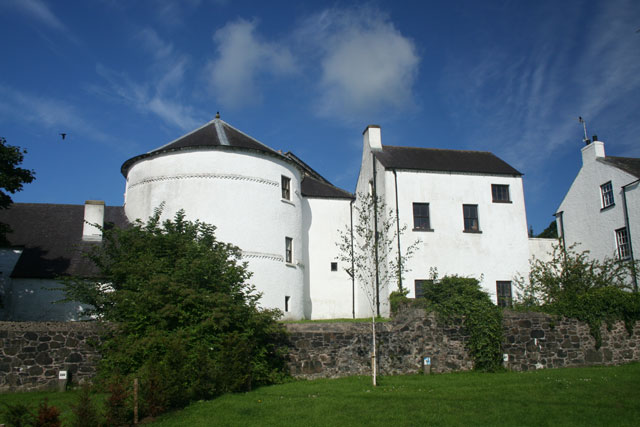
English: Bellaghy Bawn Marked as Bellaghy Castle on OS maps, this building is more correctly called a Bawn. A Bawn is a fortified house. This one was built as part of the Plantation of Ulster by the Vintners' Company of London who were granted the land around Bellaghy in 1619. It was intended as a place of refuge in times of trouble. The round tower in the photograph dates from at least 1622. |
| Ceann-là | |
| Tùs | From geograph.org.uk |
| Ùghdar | Cormac Duffin |
| Urram (required by the license) | Cormac Duffin / Bellaghy Bawn / |
| Camera location | | View this and other nearby images on: OpenStreetMap |
|---|
_heading:270.00&language=gd)
| Object location | | View this and other nearby images on: OpenStreetMap |
|---|
_heading:270.00&language=gd)
Ceadachadh

|
This image was taken from the Geograph project collection. See this photograph's page on the Geograph website for the photographer's contact details. The copyright on this image is owned by Cormac Duffin and is licensed for reuse under the Creative Commons Attribution-ShareAlike 2.0 license.
|
This file is licensed under the Creative Commons Attribution-Share Alike 2.0 Generic license.
Urram: Cormac Duffin
- Faodaidh tu:
- a cho-roinneadh – lethbhreac a dhèanamh dhen obair, a sgaoileadh is a tar-chur
- ath-mheasgachadh – an obair atharrachadh
- Fo bhuaidh nan cumhaichean a leanas:
- urram – Feumaidh tu iomradh a thoirt air an ùghdar no an neach aig a bheil cead air, dìreach mar a thoill iad (ach chan ann air dòigh a chuireas an sùilean dhaoine gu bheil iad ag aontachadh riut no ri d’ obair).
- co-roinneadh co-ionnann – Ma dh’atharraicheas tu no ma leasaicheas tu an obair seo, ’s urrainn an tionndadh ùr fon cheadachas seo no fo cheadachas coltach ris.
Eachdraidh an fhaidhle
Briog air ceann-là/àm gus am faidhle a shealltainn mar a nochd e aig an àm sin.
| Ceann-là/Àm | Dealbhag | Meud | Cleachdaiche | Beachd | |
|---|---|---|---|---|---|
| làithreach | 07:44, 5 dhen Ghearran 2011 | | 640 × 427 (59 KB) | GeographBot | == {{int:filedesc}} == {{Information |description={{en|1=Bellaghy Bawn Marked as Bellaghy Castle on OS maps, this building is more correctly called a Bawn. A Bawn is a fortified house. This one was built as part of the Plantation of Ulster by the Vintner |
Cleachdadh an fhaidhle
Tha ceangal ris an fhaidhle seo san duilleag a leanas:
Cleachdadh fhaidhlichean uile-choitcheann
Tha na uicidhean eile a leanas a’ cleachdadh an fhaidhle seo
- Cleachdadh air en.wikipedia.org
- Cleachdadh air nl.wikipedia.org
- Cleachdadh air ru.wikipedia.org
- Cleachdadh air uk.wikipedia.org